Delhi – Mumbai Expressway: Route, Tolls, Entry/Exit Points & Travel Time (2026)
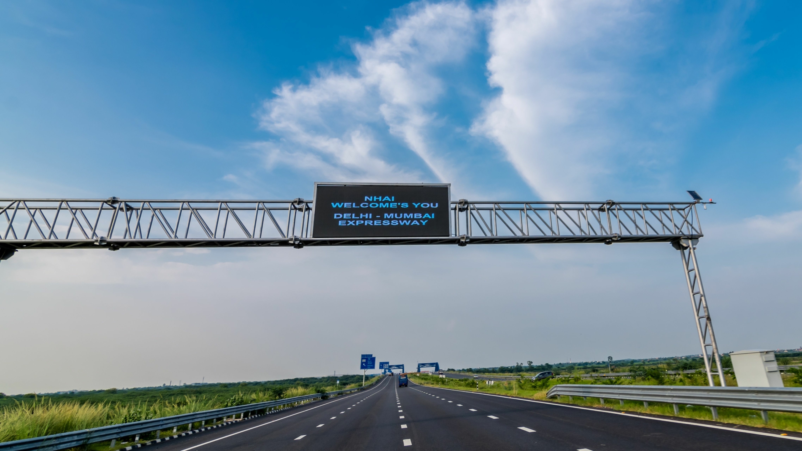
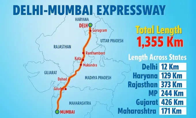
The Delhi Mumbai Expressway is a 1,350–1,386 km access-controlled highway connecting Delhi and Mumbai through six states – Delhi, Haryana, Rajasthan, Madhya Pradesh, Gujarat, and Maharashtra. Once fully operational, it is expected to reduce the Mumbai to Delhi distance to about 1,242 km and cut travel time from around 24 hours to nearly 12 hours.
In this Blog
What is the Delhi–Mumbai Expressway and why is it important?
The Delhi Mumbai Expressway is India’s longest expressway and one of the country’s largest infrastructure projects. Built by the National Highways Authority of India (NHAI), the expressway is designed as an 8-lane access-controlled corridor (expandable to 12 lanes) connecting major economic hubs across northern and western India.
Key facts about the project:
- Total length: ~1,350–1,386 km
- Estimated cost: ~₹1 lakh crore
- States covered: Delhi, Haryana, Rajasthan, Madhya Pradesh, Gujarat, Maharashtra
- Maximum speed limit: 100–120 km/h
- Expected full completion: Around 2027–2028 as remaining sections open gradually.
The expressway significantly improves logistics, tourism, and long-distance road trip connectivity between Mumbai and Delhi.
Delhi–Mumbai Expressway Route Map: Which cities does it pass through?
The expressway connects several major cities and industrial corridors across India.
Major cities along the route include:
- Gurugram / Sohna
- Dausa
- Jaipur region
- Kota
- Ratlam
- Indore
- Vadodara
- Surat
- Mumbai region (JNPT / Navi Mumbai)
The corridor passes through six states with the following approximate lengths:
| State | Approx. Expressway Length |
| Delhi | 12 km |
| Haryana | 129 km |
| Rajasthan | 373 km |
| Madhya Pradesh | 244 km |
| Gujarat | 426 km |
| Maharashtra | 171 km |
These connections allow faster road access between northern India and western industrial hubs such as Gujarat and Maharashtra.
Mumbai to Delhi Distance via the Expressway
Here is how the new expressway changes travel distances.
| Route | Distance | Average Travel Time |
| Old NH-48 route | ~1,420 km | 22–24 hours |
| Delhi–Mumbai Expressway | ~1,242 km | ~12–14 hours |
The shorter alignment reduces distance by roughly 12% and travel time by nearly half, depending on traffic and completed sections.
For travellers planning a Mumbai to Delhi road trip, this makes the journey feasible within a single long driving day.
Entry and Exit Points on the Delhi–Mumbai Expressway
The expressway operates as a controlled-access highway, meaning vehicles can enter or exit only at designated interchanges.
Important entry and exit zones include:
Delhi / NCR
- DND Flyway connection (planned)
- Meethapur
- Faridabad
- Sohna (major starting point)
Rajasthan
- Dausa
- Lalsot
- Sawai Madhopur region
- Kota
Madhya Pradesh
- Mandsaur
- Ratlam
- Garoth
Gujarat
- Dahod
- Vadodara
- Bharuch
- Surat
Maharashtra
- Vapi region
- Palghar corridor
- Navi Mumbai / JNPT
Across the entire corridor, the expressway will include over 90 entry and exit points for regional connectivity.
Delhi–Mumbai Expressway Toll System Explained
The expressway uses a closed tolling system based on distance travelled.
How tolls work
- Vehicles enter the expressway through an interchange.
- Entry point is recorded through FASTag sensors.
- Toll is calculated based on the distance travelled.
- The amount is deducted when the vehicle exits.
This system removes traditional toll plazas and reduces congestion.
Typical toll range (car)
| Section | Approx Toll |
| Short stretch | ₹85–₹100 |
| Delhi–Dausa stretch | ~₹450–₹500 |
| Long stretches | Varies by distance |
Some segments currently offer temporary toll discounts of around 50% while construction continues.
Speed Limits and Driving Rules
Drivers should follow these standard expressway rules:
- Maximum speed: 100–120 km/h depending on section
- FASTag mandatory for toll payment
- Entry restricted to motor vehicles only
- No pedestrians, tractors, or slow vehicles
The controlled-access design ensures uninterrupted travel similar to global expressways.
Key Infrastructure Features of the Expressway
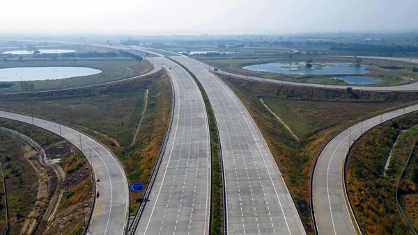
The Expressway is designed as a smart, green highway corridor.
Important features include:
- 8 lanes (expandable to 12)
- EV charging infrastructure
- Smart traffic monitoring
- Solar-powered lighting
- Wildlife crossings near forest areas
- Over 90 wayside amenities including fuel stations, food courts, and rest areas.
These features aim to improve safety and sustainability for long-distance highway travel.
Delhi to Mumbai Road Trip via the Expressway
For road trip enthusiasts, this corridor transforms the Mumbai to Delhi road trip experience.
Typical driving plan
Route example:
Delhi → Sohna → Dausa → Kota → Ratlam → Vadodara → Surat → Mumbai
Potential advantages:
- Smoother driving with fewer traffic signals
- Reduced travel fatigue
- Predictable travel times
- Better highway infrastructure
Once fully operational, drivers could potentially complete the journey in 12–14 hours of continuous driving.
Facilities Available Along the Expressway
The expressway will eventually include over 90 roadside facilities.
These include:
- Fuel stations
- EV charging points
- Rest areas
- Food courts
- Medical and trauma centres
- Highway patrol and emergency services
These amenities make long-distance road travel safer and more convenient.
Delhi–Mumbai Expressway Completion Timeline
The project has been opened in phases.
Current timeline
- 2023: Sohna–Dausa stretch opened
- 2024–2026: Multiple segments in Rajasthan and Madhya Pradesh opened
- Expected full corridor completion: 2027–2028
Delays have occurred due to construction challenges and infrastructure integration in certain sections.
Accomodations
Francolin Farmstay – New Delhi

FAQs:
The Delhi Mumbai Expressway is approximately 1,350–1,386 km long, making it India’s longest expressway connecting Delhi and Mumbai through six states including Rajasthan, Gujarat, and Maharashtra.
The Mumbai to Delhi distance via the new expressway will be roughly 1,242 km, shorter than the older NH-48 route of around 1,420 km.
The expressway is expected to reduce travel time from about 24 hours to nearly 12–14 hours, depending on driving speed, traffic, and completed sections.
The maximum permitted speed on most sections of the expressway is 100–120 km/h, depending on the zone and safety regulations.
Toll charges are calculated using a distance-based closed tolling system. FASTag sensors record the entry and exit points, and the toll amount is automatically deducted when exiting the expressway.
The expressway passes through Delhi, Haryana, Rajasthan, Madhya Pradesh, Gujarat, and Maharashtra, connecting several major cities and industrial corridors.
No. Several sections are operational, but the entire expressway is expected to be completed around 2027–2028 as remaining segments open gradually.
Yes. Once fully operational, the expressway will provide a high-speed, signal-free corridor, making the Mumbai to Delhi road trip faster, smoother, and significantly safer.
Banner Image Credit: shutterstock.com