Lama Top Trek, Harsil: 1-Hour Climb, June’s Last Clear Window (2026)
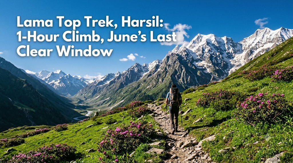
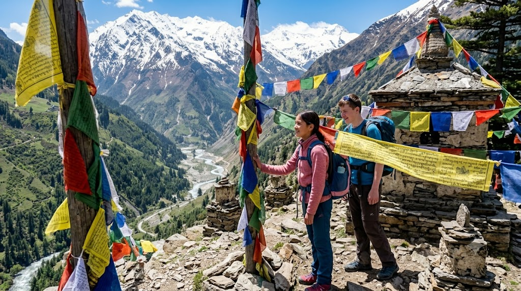
Stand on Lama Top, and the whole of Harsil Valley opens up below you — the Bhagirathi cutting a silver line through the pines, apple orchards stitched across the slopes, and the snow ridges of the Garhwal Himalayas closing the horizon. The best part? You can earn that view in about an hour of walking.
Most people planning a Harsil trip can’t tell from a quick search whether Lama Top is a serious trek or an easy stroll, how high it climbs, or — after the 2025 floods — whether the valley is even open right now. This guide answers all of that: exact distance, time, and height, the current safety picture, a route that turns the long drive into a proper holiday, and a 4-day plan that fits the trek in. If you’ve been waiting to go, June is your cue — it’s the last clear month before the monsoon shuts the valley down.
Lama Top is Harsil Valley’s easiest big-view trek — roughly 2 km one way, about 45 minutes to 1 hour up, climbing ~230 m to a ridge at around 2,900 m with 360° views of the Bhagirathi valley and snow peaks (AllTrails). It’s an easy–moderate walk most reasonably fit travellers can manage. Best done April–June and September–November; skip the July–August monsoon. The Gangotri highway reopened after the August 2025 Dharali flood and is running for the 2026 season — go now before the rains, or wait for the September reopening, and always check live road conditions first.
In this Blog
How long is the Lama Top Trek? Distance, time, and height
Lama Top is short. The trail runs about 2 km one way (some count it as a 5–6 km round trip if you start from Bagori village), takes roughly 45 minutes to 1 hour to climb, and gains around 230 m (751 ft) to a ridge sitting at approximately 2,900 m (AllTrails; montaxe). Harsil’s base elevation is about 2,620 m, so you’re not climbing far — but the payoff is wildly out of proportion to the effort.
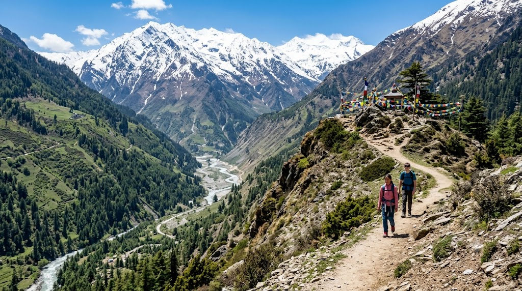
There are two common ways onto the trail: straight up from Harsil town, or from Bagori village, the Tibetan settlement hamlet just across the river. The Bagori start adds a little distance but eases you in through orchards and forest before the climb steepens. Either way, the first stretch is the hardest part — a short, sharp ascent through deodar that gets the legs and lungs working. After that, it mellows into a steady walk to the open ridge.
Allow 2–3 hours for the full round trip with photo stops. The summit is a broad grassy clearing, not a knife-edge peak, so there’s room to sit, breathe, and take in the Harsil Horn and the valley spread below.
Why does such a short trek matter so much? Because it’s the rare Himalayan viewpoint that families with kids, first-time trekkers, and older travellers can all reach — no technical skill, no overnight camp, no guide strictly required.
Lama Top trek — quick info
| Detail | Information |
|---|---|
| Distance | ~2 km one way (5–6 km round trip from Bagori) |
| Time | 45 min–1 hr up; 2–3 hrs round trip |
| Summit altitude | ~2,900 m (Harsil base ~2,620 m) |
| Elevation gain | ~230 m (751 ft) |
| Difficulty | Easy–moderate (one steep initial stretch) |
| Entry fee | Free (open forest area, no ticket) |
| Timings | Daylight only — start by mid-morning |
| Best time | April–June & September–November |
| Ideal for | Families, first-time trekkers, couples |
| Pro tip | Climb early — peaks are clearest before midday cloud builds |
From the trail: The false summit fools almost everyone. You’ll hit an open patch with a good view and think you’ve arrived — keep going another few minutes to the true ridge, where the valley reveals itself on both sides. Morning light here, before the cloud rolls in around noon, is when the snow peaks are sharpest.
Is it safe to visit Harsil Valley now? The 2025 flood update
Yes — with caution and a little planning. Vehicular movement on the Gangotri National Highway between Harsil and Dharali resumed about 24 days after the August 5, 2025, flash flood, and the road is open and running for the 2026 Char Dham season (Discover with Dheeraj). Power, water, and communication lines were restored to Harsil and the nearby villages in the weeks that followed.
What happened, briefly: on August 5, 2025, intense rainfall triggered debris-laden flash floods over Dharali and Harsil, damaging a key stretch of the highway and parts of the settlements (ISRO). Recovery has been steady, but the Harsil–Bhatwari section remains landslide-prone and is the most challenging stretch of the whole drive — which is exactly why timing matters so much here.
The single most important rule: avoid the July–August monsoon. That’s when the landslide and flash-flood risk peaks, and it’s the window through which the 2025 disaster fell in. Outside the monsoon, the valley is calm and the road is manageable.
Before you set off, check current conditions with a reliable, local source — the Uttarkashi district administration, the euttaranchal Harsil travel-news page, or the homestay you’re booking. Mountain roads change fast, and a five-minute call can save you a wasted day.
This isn’t a reason to skip Harsil. It’s a reason to go responsibly — in the right month, with conditions checked, and with a flexible day or two in your plan.
When should you do the Lama Top Trek? (And why June matters this year)
Plan for April–June or September–November. These are the windows when the weather is clear, the trail is open and the road is at its best — and the trek effectively closes during the July–August monsoon because of rain, slippery ground and landslide risk (Himalayan Dream Treks).
Here’s the timing logic for 2026, and why June is the one to circle. June is the last clear month before the monsoon arrives. After it, the valley goes quiet and risky through July and August, and the season effectively reopens in September. So you have two clean choices: go now, in the back half of June, or hold for the September–November window when the post-monsoon air is crisp and the peaks are at their clearest.
Weather-wise, summer days (May–June) are pleasant — roughly 10–20°C — with cold nights, ideal for trekking. The monsoon brings rain and instability. Winter (December–March) drops below freezing with snow, often closing the higher trails entirely. June, in short, is warm but not unbearable — close to perfect for a one-hour climb.
Are there other treks in Harsil Valley?
Yes — Lama Top is the easiest of several. Harsil sits at the centre of a cluster of short, scenic trails, so it’s worth building two or three into your trip. The standouts are Gartang Gali, a historic Indo-Tibetan wooden cliff bridge (~2.5 km, easy); the Sattal seven-lakes forest walk; and longer routes like Kyarkoti for trekkers who want a real day out (Himalayan Dream Treks).
A quick word on Gartang Gali, because it’s the one people most want to pair with Lama Top. It’s a restored 17th-century trade trail bolted to a cliff face, and it carries an entry fee of ₹150 for Indians and ₹600 for foreign nationals (Himalayan Hikers). The adjoining Nelong Valley runs deeper toward the old Tibet trade route and needs a permit from the Uttarkashi SDM/DM — open to Indian citizens only, with a season running roughly April 15 to November 15 (Discover with Dheeraj). Don’t turn up at Nelong without the paperwork; you won’t get in.
Here’s how the valley’s main treks compare, so you can pick what fits your time and fitness:
| Trek | Distance | Difficulty | Time | Entry / permit | Ideal for |
|---|---|---|---|---|---|
| Lama Top | ~2 km one way | Easy–moderate | 2–3 hrs round | Free | First-timers, families, couples |
| Gartang Gali | ~2.5 km | Easy | 2–3 hrs | ₹150 / ₹600 | Most travellers; history buffs |
| Sattal (seven lakes) | Short forest walk | Easy | 2–4 hrs | Free | Families, nature lovers |
| Kyarkoti | Multi-hour/overnight | Moderate–hard | Full day+ | None (guide advised) | Experienced trekkers |
| Nelong Valley | Drive + short walks | Easy on foot | Half/full day | SDM/DM permit (Indians only) | Curious, paperwork-ready visitors |
If you only have time for one besides Lama Top, make it Gartang Gali — the two together give you a big-view ridge climb and a piece of living Himalayan history in a single, low-effort day.
How to reach Harsil — the route, broken into easy stops
Harsil is about 220 km and 8–10 hours by road from Dehradun, the practical gateway. The nearest railhead is Rishikesh (~215 km) and the nearest airport is Jolly Grant, Dehradun (euttaranchal; Holidify). That’s far too long to drive comfortably in one go — and on a road that turns slow and winding near Harsil, trying to do it in a day is a mistake.
So break it into two days, with the journey itself becoming part of the holiday. The natural line runs Dehradun → Mussoorie → Dhanaulti/Kanatal → Uttarkashi → Harsil, and the first three are classic hill stops where you can actually overnight in comfort:
- Day 0 — land at Dehradun. Fly into Jolly Grant or arrive by train, and stay the night so you start fresh.
- Leg 1 — Dehradun → Mussoorie (~35 km, 1.5 hrs). Your first hill town. An easy, scenic warm-up with Mall Road and valley views.
- Leg 2 — Mussoorie → Dhanaulti / Kanatal (~25–60 km). Quieter, forested, and gentler on the body — a good place to acclimatise before the climb in altitude.
- Leg 3 — Kanatal → Chamba → Tehri → Uttarkashi → Harsil (~150 km). The longest and most scenic stretch runs alongside the Bhagirathi. This is also the landslide-prone Bhatwari–Harsil section, so drive it in daylight and check conditions first.
Prefer public transport? A daily bus to Gangotri leaves Dehradun and Rishikesh early — around 7 AM — and reaches Harsil by evening; shared and private cabs are easy to arrange from either city. But for the flexibility to stop, take photos, and break up the drive, a private vehicle wins.
These stops aren’t a detour. Mussoorie, Dhanaulti, and Kanatal sit right on the natural Dehradun-to-Gangotri line, so each night out and back is genuinely en route — you’re not adding distance, you’re adding comfort.
A 4-day Harsil itinerary with Lama Top
Four days is the sweet spot: enough to break the drive, acclimatise gently, and still have a full morning for the trek. Here’s a plan that uses the route above.
Day 1 — Arrive Dehradun, overnight in Mussoorie. Land or train, drive up to Mussoorie, and spend the evening at Mall Road. Easy start, no rush.
Day 2 — Mussoorie → Dhanaulti/Kanatal. A short, pretty drive into quieter hills. Relax, walk the deodar forests, and let your body adjust to the altitude before you go higher.
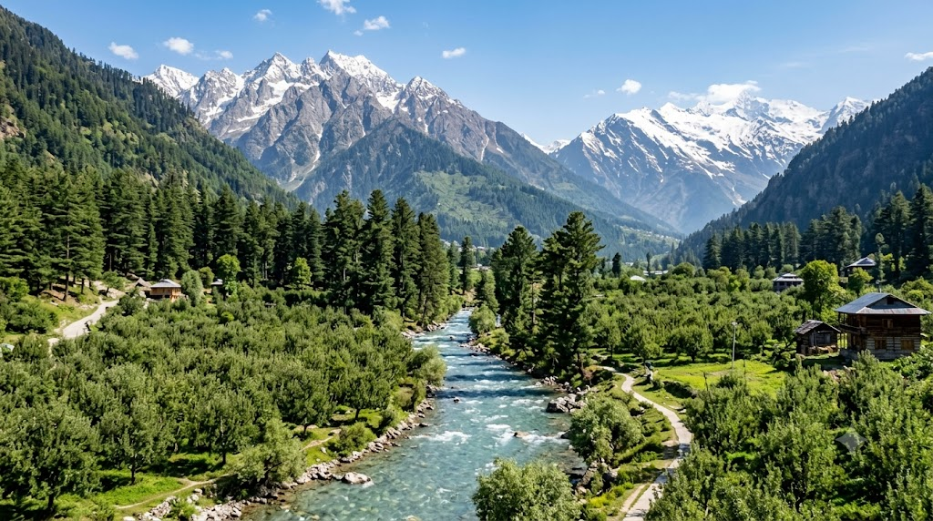
Day 3 — Drive to Harsil. The long, scenic leg via Uttarkashi. Arrive by late afternoon, settle in, and take an easy evening walk to the villages of Bagori and Mukhba and the apple orchards.
Practical note — Mukhba: This is the winter seat of Goddess Ganga, where the deity moves when the Gangotri temple closes for the season. Entry: free. Best time: late afternoon. How to reach: a few km from Harsil by road/walk. Ideal for: anyone interested in local faith and culture.
Day 4 — Lama Top in the morning, Gartang Gali or Sattal after. Climb Lama Top early for the clearest peaks, then spend the afternoon at Gartang Gali (~2.5 km, ₹150 entry) or the Sattal lakes. If you have a spare half-day, Gangotri is about 25 km / 1 hour on, and Gangnani’s natural hot springs sit roughly 20 km away (Holidify).
Practical note — Gangnani hot springs: Entry: free. Timings: daylight. Best time: a cold afternoon. How to reach: ~20 km from Harsil on the Gangotri road. Time required: 1–2 hrs. Ideal for: a soak after a trek. Pro tip: carry a change of clothes and a towel.
Want it shorter? Drop Day 2 and stay one night each in Mussoorie and Harsil for a tighter 3-day version — though the extra acclimatisation night genuinely helps.
What to pack and know before you go
A few simple things make this trip smoother — and a couple are non-negotiable at altitude.
- Layers and a windproof jacket. Even in June, the ridge is breezy and nights are cold.
- Trail shoes with grip. That first steep stretch is loose underfoot.
- Water and snacks. There are no shops on the trail; carry at least a litre.
- Sun protection. High-altitude UV is strong — cap, sunglasses, sunscreen.
- Cash. Connectivity and card machines are limited in the valley.
- Offline maps. Phone signal is patchy, more so since the 2025 floods.
- ID and permits. Lama Top needs no permit. Gartang Gali charges ₹150/₹600 entry, and Nelong Valley requires an Uttarkashi SDM/DM permit (Indians only, season ~April 15–November 15) (Discover with Dheeraj).
One health note: Harsil sits at ~2,620 m, so take Day 1 easy, hydrate well, and don’t sprint the first climb. That’s exactly why the itinerary above builds in an acclimatisation night before you go higher.
And start early. The single best habit in these hills is to be on the trail by mid-morning — the views are clearest, the weather is calmest, and you’ve got the whole day in hand if the road throws up a surprise.
Where to stay near Harsil — and the StayVista stops on the way
In Harsil itself, stay in town or in the Bagori/Chholmi villages — riverside homestays and tented stays here put you within minutes of the Lama Top trailhead, which is exactly what you want for an early start. StayVista doesn’t have a property inside the Gangotri valley, so for the trek night, book a local in-valley stay.
Where StayVista comes in is the journey. Because you’re breaking an 8–10 hour drive into two days, a comfortable base in Dehradun, Mussoorie, or Kanatal turns the travel into part of the holiday rather than an ordeal:
- Villa Vaari, Dehradun — a 4-bedroom villa with a private pool, gazebo, and 360° views of the surrounding hills. The easy arrival-night base, close to Jolly Grant airport and the railhead, so you start the drive fresh.
- Arncliff Villa, Mussoorie — a cosy 2-bedroom home about 5 minutes from Mall Road, with an outdoor fireplace and lush valley views. Ideal for couples and small families.
- Mellow Cottage, Mussoorie — a 3-bedroom cottage with an indoor fireplace and valley views near Mall Road, good for families wanting a comfortable Mussoorie night en route.
- Amala Villa, Kanatal — a 6-bedroom villa with a private pool, fireplace, library, and barbecue, about 46 km from Mussoorie Mall Road and 17 km from Dhanaulti. Best for larger groups who want one relaxed mountain base before the final push to Harsil.
The idea is simple: do the trek from Harsil, and bookend the journey with a night at Arncliff Villa in Mussoorie or Amala Villa in Kanatal so the drive up and back is genuinely enjoyable.
Frequently Asked Questions
Lama Top is roughly 2 km one way and takes about 45 minutes to 1 hour to climb, gaining around 230 m of elevation (AllTrails). Allow 2–3 hours for the full round trip with photo stops. It’s one of the shortest big-view treks in the Garhwal Himalayas.
The Lama Top summit sits at approximately 2,900 m, with the Harsil base at about 2,620 m and an elevation gain of roughly 230 m (751 ft) along the trail (AllTrails). The altitude is modest, but enough that you should acclimatise for a day before climbing.
Yes, with caution. The Gangotri highway between Harsil and Dharali reopened about 24 days after the August 2025 flash flood and is running for the 2026 season (Discover with Dheeraj). Avoid the July–August monsoon and check live road conditions with local authorities before travelling.
The trek covers about 2 km one way from the Harsil/Bagori trailhead — closer to 5–6 km round trip if you start from Bagori village (montaxe). The trailhead is within easy reach of Harsil town, so you can walk to the start.
It’s easy to moderate. The only real challenge is a short, steep stretch at the start through the forest; after that the trail levels into a comfortable walk to the ridge. Most reasonably fit travellers, including families with older children, can complete it in about an hour.
The ideal windows are April–June and September–November, when the weather is clear and the trail is open (Himalayan Dream Treks). Avoid July–August (monsoon). June is the last clear month before the rains; the season reopens in September.
The bottom line
Lama Top is the rare Himalayan trek that asks very little and gives back a lot — about an hour of climbing for a 360° view over Harsil Valley and the snow peaks beyond. It’s easy enough for families, free to do, and reachable on a short morning. The catch is timing: with the monsoon closing the valley through July and August, June is your last clear window before the rains, and September is when the season starts again.
So if Harsil’s been on your list, this is the month to move — go responsibly, check the road, and give yourself a day to acclimatise on the way up. Plan the route in two comfortable legs, book your en-route stay at Villa Vaari in Dehradun or Arncliff Villa in Mussoorie, and let the drive be part of the trip rather than the price of it.
Ready when you are. The ridge isn’t going anywhere — but the clear-weather window is.