Monsoon Group Bike Trips in India: 14 Best Routes 2026
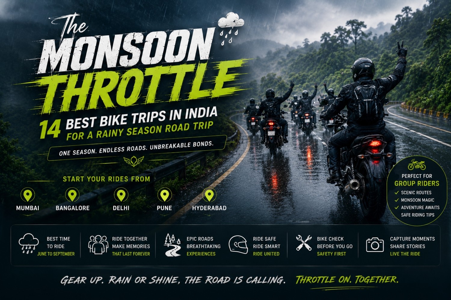
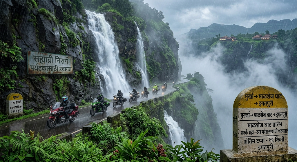
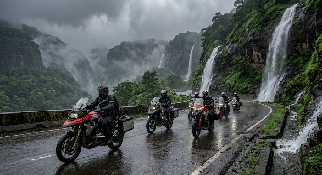
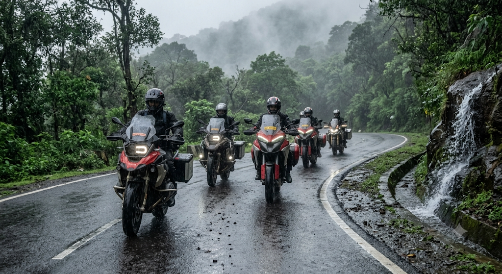
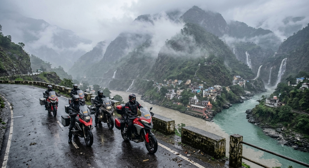
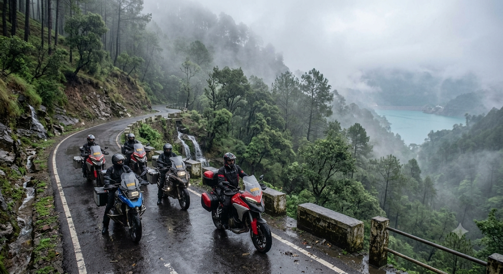
The 14 best Monsoon Group Bike Trips in India for the 2026 season cover Western Ghats classics from Mumbai and Pune, lush Karnataka loops from Bangalore, Himalayan foothills from Delhi, Deccan greens from Hyderabad, Eastern Ghats rides from Chennai, and Saputara from Ahmedabad. Each route below is a 3-day plan with distances, refreshed road conditions for June 2026, and monsoon-only roadside sights like Tamhini Ghat waterfalls, Bisle Ghat mist banks, and Devprayag’s swollen Ganga.
If you have only one weekend, the safest and most scenic picks for first-timers are Mumbai → Tamhini Ghat → Kashid (370 km loop), Bangalore → Sakleshpur → Bisle Ghat (560 km loop), and Pune → Bhimashankar → Malshej Ghat (390 km loop).
In this Blog
Quick Info Table
| Detail | Information |
| Best months for group bike trips | Mid-July to mid-September 2026 |
| Ideal group size | 8-12 riders (best cost-sharing) |
| Average daily ride distance | 150-220 km |
| Ideal duration | 3 days / 2 nights per route |
| Recommended bikes | 350cc-650cc adventure tourers |
| Average budget per rider | ₹6,500-₹12,000 (fuel + stay + food) |
| Mandatory gear | Waterproof riding jacket, knee guards, rain cover for luggage, mesh gloves, anti-fog visor |
| Best fuel buffer | Top up every 100 km in ghats |
Why Monsoon Group Bike Trips in India Are Worth the Rain
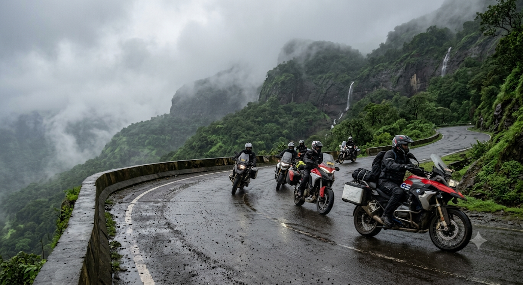
Riding in the rains is a different sport. Waterfalls run full, the Sahyadris turn emerald, traffic thins out, and ghat roads feel like riding through clouds. Monsoon Group Bike Trips in India also mean fewer tourists at viewpoints and significantly cooler riding temperatures — most Western Ghats routes drop to 18-24°C between July and September, compared to 32-38°C in April-May.
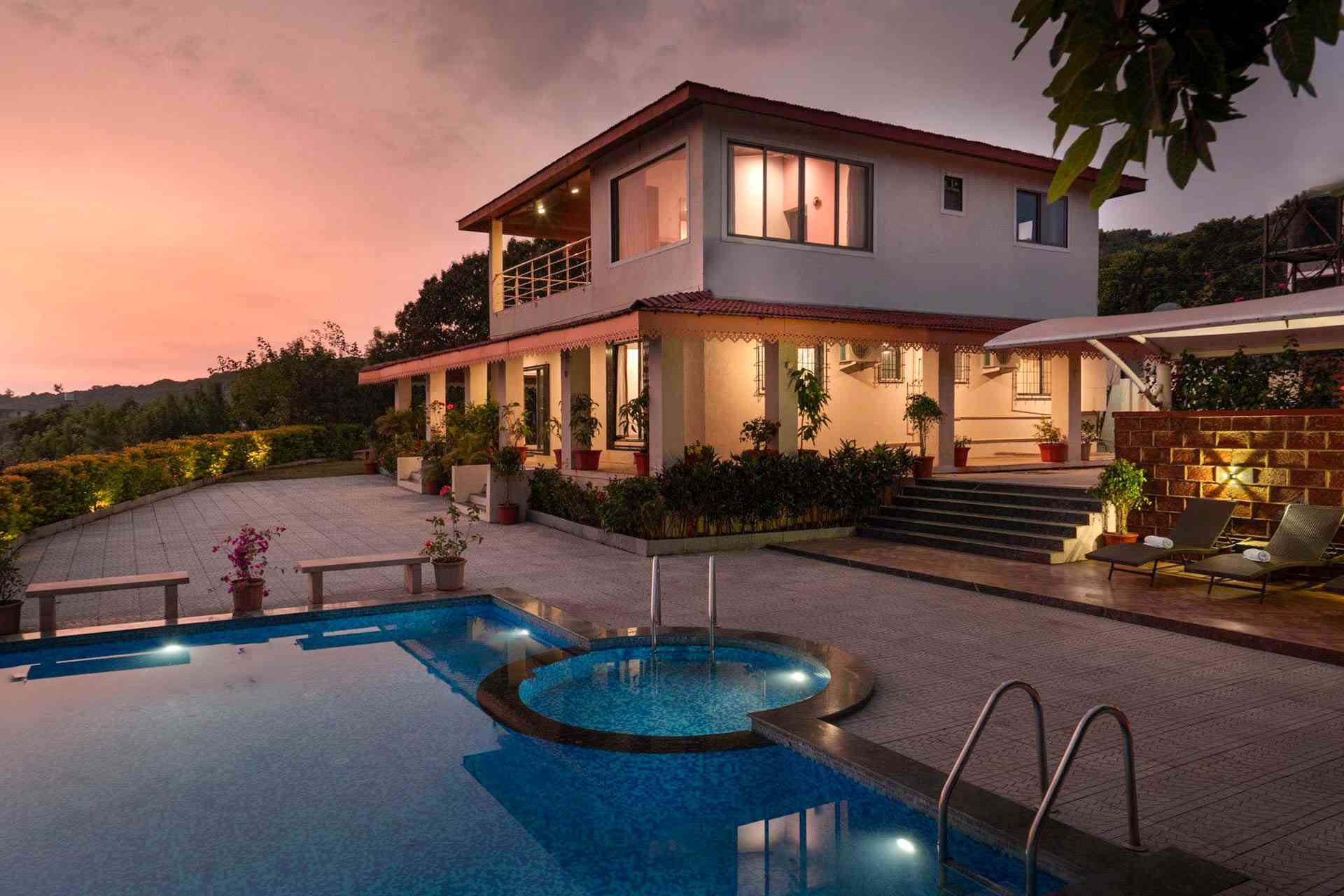
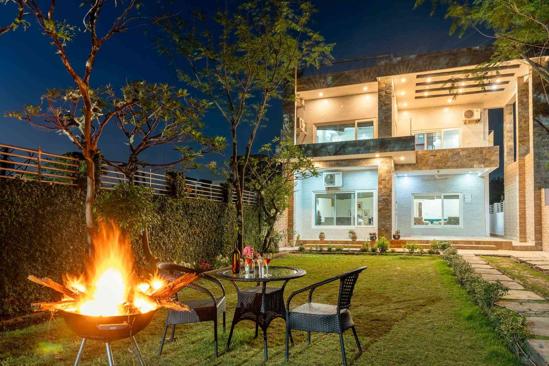
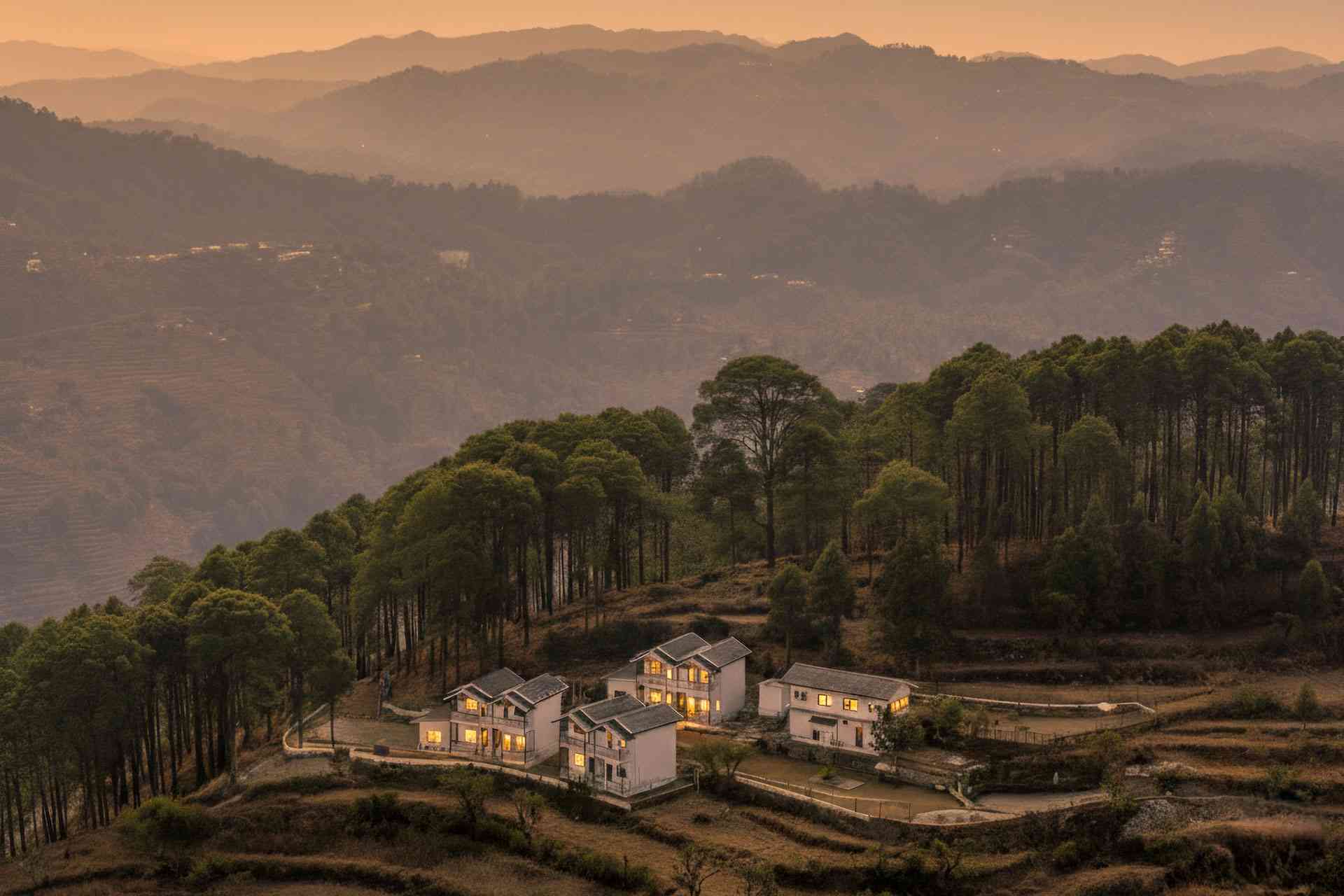
The places to stay for the halt on every route below are group villas designed for 8-12 riders. When the cost of a private villa, a personal chef, and covered parking is distributed across a group of 8-12 people, monsoon biking suddenly becomes one of the most affordable luxury holidays in India — typically ₹2,500-₹4,500 per rider per night for properties that would cost ₹15,000+ per night solo. Group bookings unlock the luxury without compromising the comfort.
At StayVista, our travel team has been mapping rider-friendly routes since 2018, and we’ve seen a sharp rise in groups asking for villas with secure parking, drying racks, and easy ghat access. This guide pulls together the 14 most reliable Monsoon Group Bike Trips in India for 2026, with the latest road updates from the Maharashtra PWD, Karnataka State Highways Authority, BRO (Border Roads Organisation), and Telangana Roads & Buildings department portals.
Monsoon Riding Essentials Before You Roll Out
Mid-July to mid-September is the sweet spot for Monsoon Group Bike Trips in India — peak greenery, but past the dangerous early-monsoon landslide window.
· Tyres: Replace if tread depth is below 2 mm. Wet ghats demand grip.
· Brakes: Get brake pads and brake fluid checked. Wet brake response lag is real.
· Chain: Use wax-based chain lube, not WD-40 — water washes WD-40 off in minutes.
· Visibility: Yellow-tinted visor or anti-fog spray. Carry a clean microfibre.
· Group comms: Bluetooth intercoms (Cardo or Sena) save lives on blind ghat curves.
· Fuel rule: Refuel at 50% tank in the ghats. Stations are sparse.
· Buddy system: Ride in 2s with a 5-second gap. Lead and sweeper riders fixed.
Group Bike Trips From Mumbai (Monsoon)
Mumbai sits at the gateway to the Sahyadris, which makes it the best launch pad for Monsoon Group Bike Trips in India. Three routes below cover beach, ghat, and lake terrain — pick by skill level.
Route 1: Mumbai → Tamhini Ghat → Kashid Beach
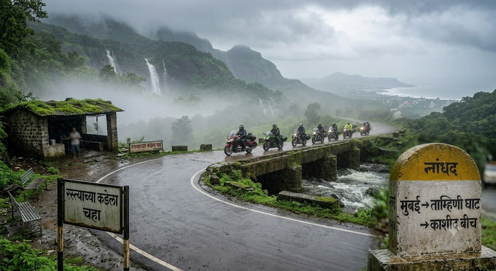
Route Introduction
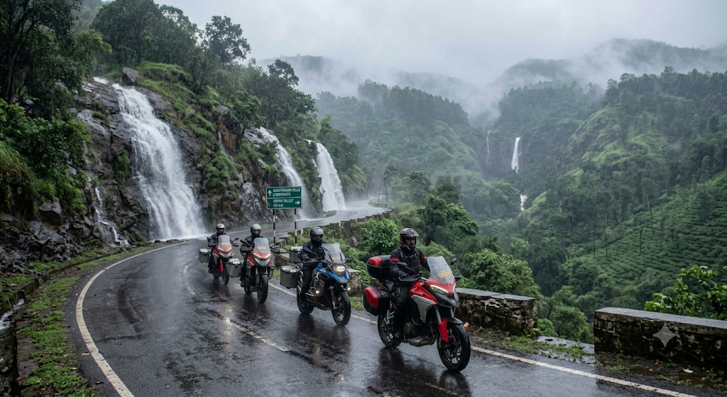
Tamhini Ghat is the most photographed monsoon road in Maharashtra, with over 30 unnamed waterfalls active between July and September. Pair it with the quieter Kashid Beach (over 10 km of clean grey sand) and you get a complete monsoon weekend — green ghats, then green coast. This is the most beginner-friendly route from Mumbai because the ghat is short and the rest is flat coastal road.
Distance | Duration
| Leg | Route | Distance | Time |
| Day 1 | Mumbai → Tamhini → Mulshi Lake → Kolad | 165 km | 5-6 hrs |
| Day 2 | Kolad → Murud → Kashid | 95 km | 3 hrs |
| Day 3 | Kashid → Alibaug → Mumbai (via RoRo) | 110 km | 4 hrs |
| Total | ~370 km |
Ride Plan (3-Day Itinerary)
Day 1 — Mumbai to Kolad via Tamhini Ghat: 6:30 AM start from Sion. Breakfast at Vadkhal Naka by 9 AM. Enter Tamhini Ghat by 11 AM. Stop at Devkund waterfall viewpoint (no trek in monsoon — flash flood risk). Reach Kolad by 4 PM.
Day 2 — Kolad to Kashid via Murud-Janjira: Late breakfast, then ride coastal road via Roha and Murud. See Murud-Janjira Fort from the jetty (boats run only in calm tides). Reach Kashid by sunset.
Day 3 — Kashid to Mumbai via Mandwa-RoRo: Slow morning at beach. Ride to Mandwa jetty by 1 PM. RoRo ferry to Bhaucha Dhakka with bikes (book on M2M1 app). Reach Mumbai by 5 PM.
Monsoon Special Sightseeing Stops (Roadside, No Long Walks)
· Tamhini Ghat waterfalls cluster — over a dozen cascades visible from the road shoulder between km 28-44. Park on widened shoulders only.
· Plus Valley viewpoint — railing-side viewpoint on the Mulshi-Tamhini road. Park within 5 metres.
· Mulshi Lake roadside — multiple lay-bys directly above the dam backwaters.
· Pawana spillway (en route detour) — water-overflow photo spot from the road bridge.
· Kashid Beach — bikes can park 10 metres from the sand on the access road.
· Murud-Janjira jetty view — fort visible from the parking right by the bike.
Road Conditions & Riding Safety Notes (June 2026 Update)
· Mumbai-Pune Expressway: Bikes prohibited. Use NH-48 via Khopoli.
· Tamhini Ghat (MDR-55): Patched in May 2026 by Maharashtra PWD; surface good but moss-prone after the first heavy spell.
· Mulshi-Tamhini stretch has 7 hairpins — drop to 30 kmph after rain.
· Kashid coastal road has 2 low-water crossings near Revdanda; check tide chart on IMD app.
· Mobile signal patchy between Mulshi and Tamhini for 22 km.
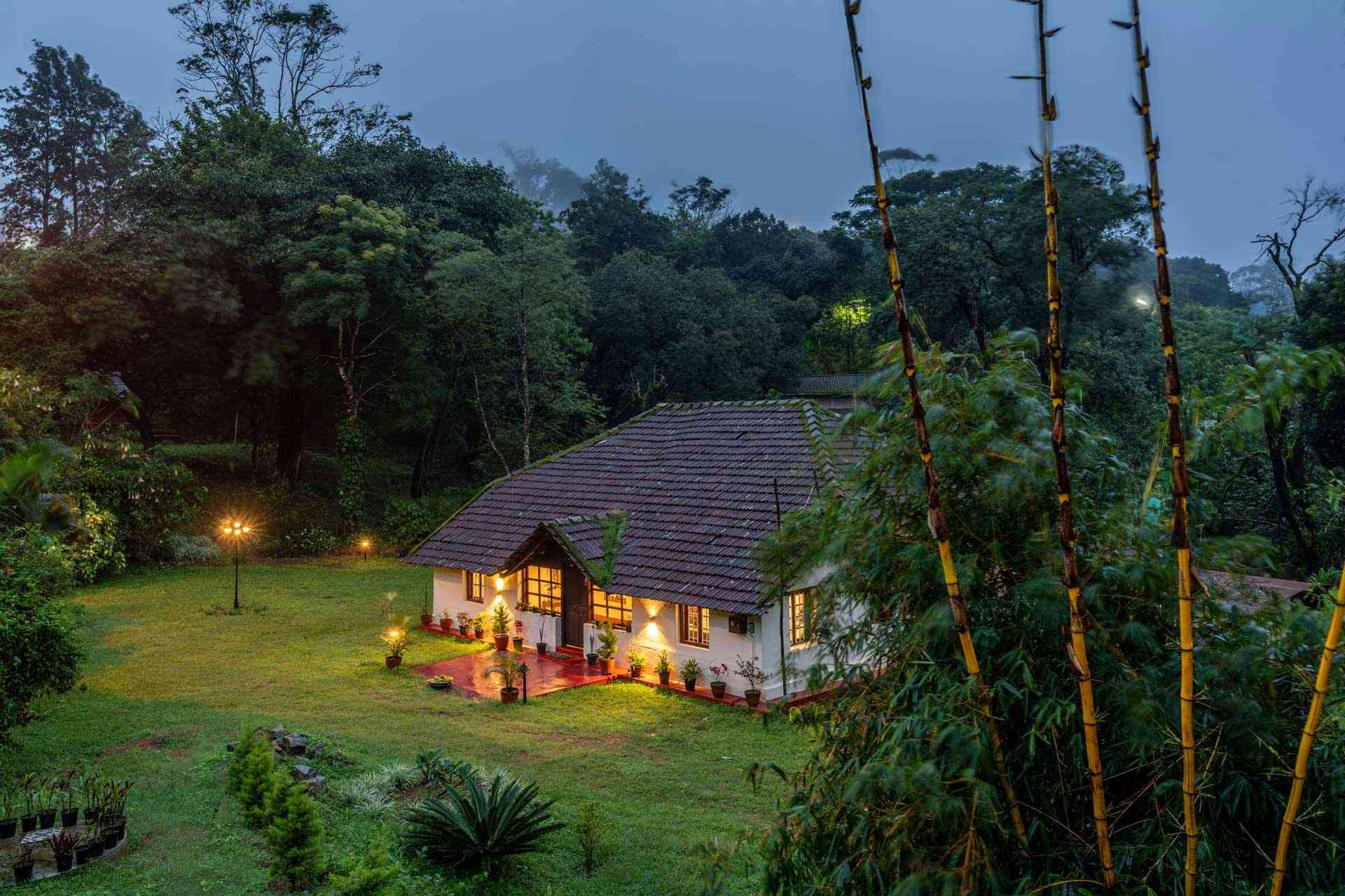
Places to Stay for the Halt (Group Villas)
Route 2: Mumbai → Malshej Ghat → Igatpuri
Route Introduction
Malshej Ghat in monsoon is a meteorological event — clouds physically pour through the road cuts. Combine it with Igatpuri’s Bhatsa River valley and you have one of the highest-altitude rides from Mumbai, peaking at 700 m. The route is dramatic but demands experience; first-time monsoon riders should pick Tamhini instead.
Distance | Duration
| Leg | Route | Distance | Time |
| Day 1 | Mumbai → Kalyan → Malshej Ghat → Pimpalgaon Joga | 145 km | 5 hrs |
| Day 2 | Pimpalgaon → Kasara → Igatpuri | 110 km | 4 hrs |
| Day 3 | Igatpuri → Bhandardara loop → Mumbai | 195 km | 6 hrs |
| Total | ~450 km |
Ride Plan (3-Day Itinerary)
Day 1 — Mumbai to Pimpalgaon Joga: Leave Mumbai by 6 AM via Eastern Express Highway → Kalyan → Murbai → Malshej. Lunch at MTDC Flamingo Resort viewpoint. Reach Pimpalgaon Joga lakeside by 4 PM.
Day 2 — Pimpalgaon to Igatpuri via Kasara Ghat: Ride to Junnar (Shivneri Fort photo halt), then Otur, Sakhri to Kasara. Reach Igatpuri by 3 PM. Visit Camel Valley and Tringalwadi Fort base.
Day 3 — Igatpuri to Mumbai via Bhandardara: Detour to Bhandardara via Ghoti — see Wilson Dam in spillway action. Lunch at Shendi village. Return via NH-160 to Mumbai by 7 PM.
Monsoon Special Sightseeing Stops (Roadside)
· Malshej Ghat waterfall cluster — 12+ cascades between km 78-94, viewable from the road’s edge.
· MTDC Flamingo Resort viewpoint — bike parking 20 metres from the cliff railing.
· Pimpalgaon Joga reservoir lay-by — flamingo flocks visible in late August from the road shoulder.
· Wilson Dam spillway, Bhandardara — photograph from the bridge without dismounting far.
· Camel Valley viewpoint, Igatpuri — roadside platform; park beside the bike.
· Shendi village lakefront — bikes park on the lakeside road.
Road Conditions & Riding Safety Notes (June 2026 Update)
· NH-61 Malshej Ghat: Repaved December 2025, surface excellent.
· Landslide-prone zone at km 84-88; NHAI has installed rockfall fencing post-2024.
· Kasara Ghat reverse curves are slippery — 12 minor accidents reported July 2025 per Thane RTO.
· Bhandardara approach road (SH-44) has 4 km of broken patches near Shendi.
· Carry a tow rope — recovery is hard between Malshej and Junnar. Places to Stay for the Halt (Group Villas)
Places to Stay for the Halt (Group Villas)

Route 3: Mumbai → Lonavala → Bhandardara
Route Introduction
This is the high-mileage member of our 14-route list — a 540 km triangular loop that strings together Lonavala’s Bhushi Dam, Bhandardara’s Wilson Dam, and the Kasara descent. It works best for experienced groups on tourer bikes (Himalayan 450, Tiger 400, Versys 650) who want big-distance days without highway monotony.
Distance | Duration
| Leg | Route | Distance | Time |
| Day 1 | Mumbai → Lonavala → Lavasa | 145 km | 5 hrs |
| Day 2 | Lavasa → Pune bypass → Bhandardara | 195 km | 6 hrs |
| Day 3 | Bhandardara → Igatpuri → Mumbai | 200 km | 6 hrs |
| Total | ~540 km |
Ride Plan (3-Day Itinerary)
Day 1 — Mumbai to Lavasa: 6 AM rollout, breakfast at Khopoli McDonald’s. Detour to Lonavala for Bhushi Dam and Tiger Point. Reach Lavasa by 5 PM via Mulshi.
Day 2 — Lavasa to Bhandardara: Skip Pune city. Take Pune bypass → Sangamner → Akole → Bhandardara. Lunch at Akole. Reach Wilson Dam by 5 PM.
Day 3 — Bhandardara to Mumbai via Igatpuri: Sunrise at Arthur Lake. Ride to Igatpuri (Sandhan Valley viewpoint), then Kasara → Mumbai via NH-160.
Monsoon Special Sightseeing Stops (Roadside)
· Bhushi Dam roadside spillway — view from the road without long parking walks.
· Tiger’s Leap, Lonavala — bike parking 30 metres from the viewpoint railing.
· Aamby Valley road waterfalls — multiple roadside cascades on the Lavasa approach.
· Wilson Dam, Bhandardara — photograph the spillway from the bridge.
· Arthur Lake lay-by — sunrise spot directly on the road.
· Sandhan Valley viewpoint at Samrad — clouds visible from the road’s edge.
Road Conditions & Riding Safety Notes (June 2026 Update)
· NH-48 Mumbai-Lonavala: Concretised stretches, slippery in first rain.
· Lonavala internal roads chaotic on weekends; avoid Saturday-Sunday between 11 AM-5 PM.
· Lavasa road via Mulshi has 18 km of narrow ghat — single file only.
· Sangamner-Akole road resurfaced February 2026.
· Bhandardara loop has 6 unguarded hairpins; install bike LED bar lights for fog.
Places to Stay for the Halt (Group Villas)
Group Bike Trips From Pune (Monsoon)
Pune is closer to the Western Ghats than Mumbai is, which means more ride time and less city escape. The two routes below are top picks for Pune-based groups planning Monsoon Group Bike Trips in India in 2026.
Route 4: Pune → Mahabaleshwar → Tapola
Route Introduction
Mahabaleshwar is India’s most popular monsoon hill station, and Tapola — known as “mini-Kashmir” — extends it with reservoir views that rival Pangong in clear weather. This is the most photogenic Pune-origin ride, and the only one with a guaranteed strawberry-tea-and-rain combo.
Distance | Duration
| Leg | Route | Distance | Time |
| Day 1 | Pune → Panchgani → Mahabaleshwar | 125 km | 4 hrs |
| Day 2 | Mahabaleshwar → Tapola → return | 60 km | 3 hrs (loop) |
| Day 3 | Mahabaleshwar → Wai → Pune | 130 km | 4 hrs |
| Total | ~315 km |
Ride Plan (3-Day Itinerary)
Day 1 — Pune to Mahabaleshwar: 8 AM start via NH-48 → Surur → Wai → Panchgani → Mahabaleshwar. Lunch at Panchgani (Mapro Garden). Reach Mahabaleshwar by 2 PM. Evening at Venna Lake.
Day 2 — Tapola Day Ride: Light gear day. Ride to Tapola via Bamnoli for Shivsagar boat ride. Picnic at Tapola. Return to Mahabaleshwar by 6 PM.
Day 3 — Mahabaleshwar to Pune via Wai: Sunrise at Wilson Point. Breakfast, then ride to Wai (Dholya Ganpati temple). Continue to Pune via Surur. Reach Pune by 5 PM.
Monsoon Special Sightseeing Stops (Roadside)
· Lingmala Waterfall — visible from the access road; park 20 metres away.
· Dhobi Waterfall viewpoint — bike parking next to the viewing deck.
· Tapola reservoir lay-by — multiple roadside spots above the backwaters.
· Arthur’s Seat misty cliffs — bike park within 30 metres of the cliff.
· Wilson Point — roadside sunrise viewpoint with parking.
· Krishna Bai temple road — riverside Krishna source seen from the road.
Road Conditions & Riding Safety Notes (June 2026 Update)
· NH-48 Pune-Satara: Excellent, but high winds at Khambatki Tunnel.
· Panchgani-Mahabaleshwar Pasarni Ghat: Newly resurfaced February 2026.
· Mahabaleshwar-Tapola road narrow with blind curves; horn at every hairpin.
· Pratapgad approach has 8 km broken patches.
· Fog after 6 PM at Wilson Point — avoid night rides.
Places to Stay for the Halt (Group Villas)
Route 5: Pune → Bhimashankar → Malshej Ghat
Route Introduction
A compact loop perfect for Pune groups with only a weekend. The ride climbs to Bhimashankar (one of the 12 Jyotirlingas), descends through Manchar, then loops up Malshej Ghat for the cloud-through-the-road experience. This route packs the most variety into the shortest distance from Pune.
Distance | Duration
| Leg | Route | Distance | Time |
| Day 1 | Pune → Khed → Bhimashankar | 110 km | 4 hrs |
| Day 2 | Bhimashankar → Manchar → Malshej Ghat | 130 km | 5 hrs |
| Day 3 | Malshej → Junnar → Pune | 150 km | 5 hrs |
| Total | ~390 km |
Ride Plan (3-Day Itinerary)
Day 1 — Pune to Bhimashankar: 7 AM start, breakfast at Khed. Climb to Bhimashankar by 12 PM via Ghodegaon. Darshan and lunch at Bhimashankar village. Stay in nearby village homestays.
Day 2 — Bhimashankar to Malshej Ghat: Descend to Manchar via Ghodegaon. Lunch at Otur. Climb Malshej Ghat from Junnar side. Stay at lakeside near Pimpalgaon Joga.
Day 3 — Malshej Ghat to Pune via Junnar: Visit Shivneri Fort photo-point. Lunch at Narayangaon. Return to Pune via NH-60. Reach Pune by 5 PM.
Monsoon Special Sightseeing Stops (Roadside)
· Gupt Bhimashankar viewpoint — visible from the temple road approach.
· Malshej Ghat cloud zones — km 84-92 roadside cloud-blanket spots.
· Hadsar Fort base viewpoint — viewable from the road below.
· Pimpalgaon Joga lakeside lay-by — direct lake views from the road.
· Khed waterfalls — roadside cascades en route Bhimashankar.
· Nimgiri-Hanumantgad twin-fort view — visible from the Junnar approach road.
Road Conditions & Riding Safety Notes (June 2026 Update)
· Khed-Bhimashankar road has 18 km of single-lane ghat — go single file.
· Bhimashankar village parking limited; reach by noon to avoid jams.
· Manchar-Otur road has 6 km of crater-grade potholes (PWD work scheduled August 2026).
· Malshej Ghat — see Route 2 notes.
· Carry physical map; Google Maps reroutes via flooded village roads after heavy rain.
Places to Stay for the Halt (Group Villas)

Group Bike Trips From Bangalore (Monsoon)
Karnataka’s southwest belt — Coorg, Chikmagalur, Sakleshpur — sees some of the heaviest rainfall in peninsular India between June and September. These three Bangalore-origin routes are the most reliable Monsoon Group Bike Trips in India in the south.
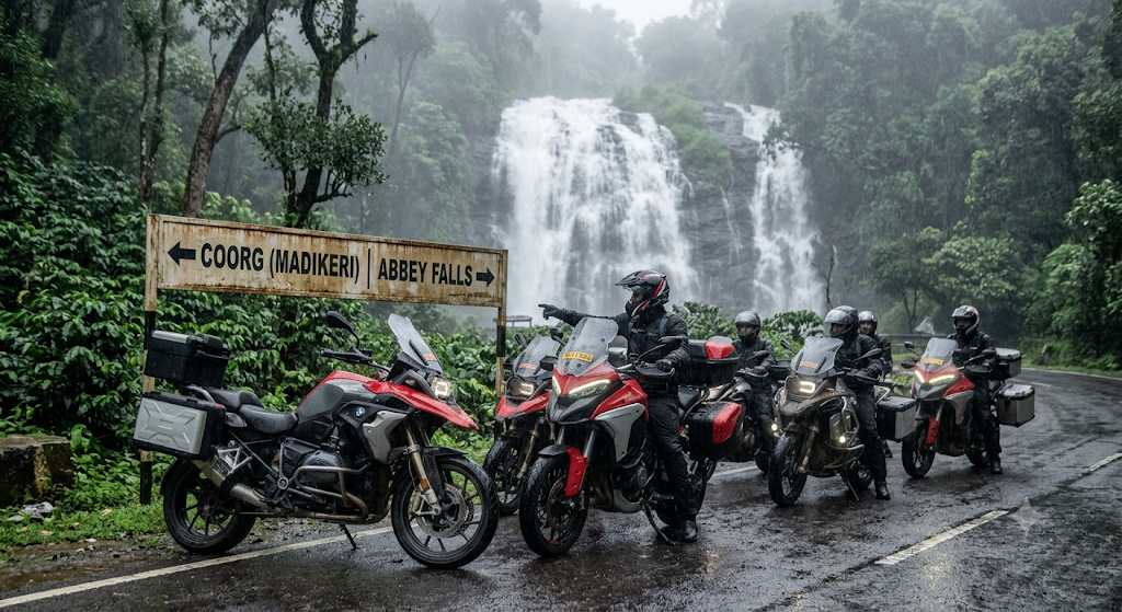
Route 6: Bangalore → Coorg (Madikeri) → Abbey Falls
Route Introduction
Coorg in monsoon is a different country. Coffee estates drip, brooks turn into torrents, and Madikeri’s mist swallows entire valleys. This is the most popular monsoon ride from Bangalore, and properties book out 4-6 weeks ahead for weekends in August.
Distance | Duration
| Leg | Route | Distance | Time |
| Day 1 | Bangalore → Mysuru → Madikeri | 265 km | 7 hrs |
| Day 2 | Madikeri → Abbey Falls → Talakaveri | 60 km | 3 hrs (loop) |
| Day 3 | Madikeri → Mysuru → Bangalore | 270 km | 7 hrs |
| Total | ~595 km |
Ride Plan (3-Day Itinerary)
Day 1 — Bangalore to Madikeri: 5:30 AM rollout to beat Mysuru highway traffic. Breakfast at Maddur. Lunch at Kushalnagar. Reach Madikeri by 3 PM.
Day 2 — Coorg Loop: Visit Abbey Falls and Raja’s Seat for sunset, with a roadside halt at Talakaveri (Kaveri source). Stop at the Tibetan Golden Temple, Bylakuppe.
Day 3 — Madikeri to Bangalore: Early start by 6 AM. Coffee at Sakleshpur-bound estates. Lunch at Mandya. Return via Mysuru Expressway service road. Reach Bangalore by 4 PM.
Monsoon Special Sightseeing Stops (Roadside)
· Abbey Falls — view platform 50 metres from the road; bike parking on the access road.
· Raja’s Seat sunset deck — direct roadside parking.
· Talakaveri Kaveri source — view the spring rise from the road approach.
· Tibetan Golden Temple — bikes park in the temple’s roadside lot.
· Mandalpatti road waterfalls — multiple roadside flows on the climb (jeep-only beyond village).
· Harangi Dam viewpoint — backwaters visible from the road bridge.
Road Conditions & Riding Safety Notes (June 2026 Update)
· Bangalore-Mysuru Expressway: Two-wheelers prohibited. Use NH-275 service road.
· Mysuru-Madikeri (SH-88): Resurfaced January 2026.
· Madikeri internal roads slippery from moss and oil; drop to 20 kmph.
· Fallen trees common in August — group needs a 4-metre tow strap.
· Leech socks recommended for any short trail detour.
Places to Stay for the Halt (Group Villas)
Route 7: Bangalore → Chikmagalur → Mullayanagiri
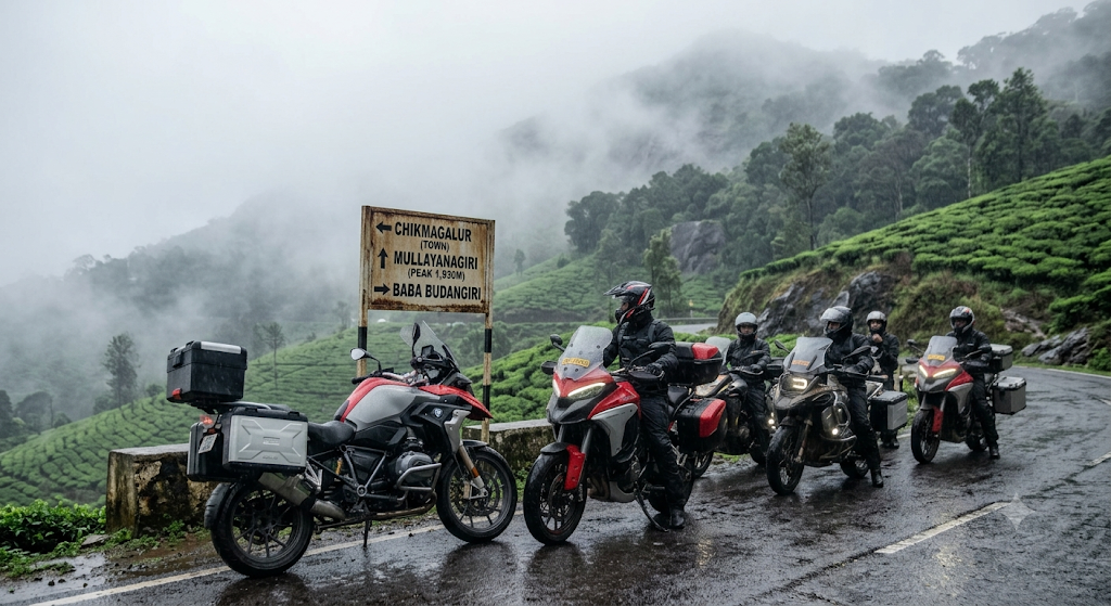
Route Introduction
Chikmagalur is Karnataka’s coffee capital and Mullayanagiri is the state’s highest peak (1,930 m). This route gives groups a high-altitude monsoon experience without the heavy traffic of Coorg. For Bangalore groups asking which monsoon route is still uncrowded, this is the answer.
Distance | Duration
| Leg | Route | Distance | Time |
| Day 1 | Bangalore → Chikmagalur via Hassan | 245 km | 6 hrs |
| Day 2 | Chikmagalur → Mullayanagiri → Baba Budangiri | 75 km | 4 hrs (loop) |
| Day 3 | Chikmagalur → Belur → Bangalore | 250 km | 6 hrs |
| Total | ~570 km |
Ride Plan (3-Day Itinerary)
Day 1 — Bangalore to Chikmagalur: 6 AM start via Tumkur → Hassan → Chikmagalur. Breakfast at Kunigal. Lunch at Hassan. Reach Chikmagalur by 2 PM. Evening at Hirekolale Lake.
Day 2 — Mullayanagiri-Baba Budangiri Loop: Light gear day. Ride to Mullayanagiri peak road (bikes go up to 1.5 km from summit). Continue to Baba Budangiri dargah. Return via Manikyadhara Falls roadside view.
Day 3 — Chikmagalur to Bangalore via Belur: Morning at Belur Hoysala temple. Lunch at Hassan. Return to Bangalore by 6 PM.
Monsoon Special Sightseeing Stops (Roadside)
· Hirekolale Lake — roadside lay-by; bike parking 5 metres from water.
· Mullayanagiri road hairpins — cloud-cover photo spots on the climb.
· Baba Budangiri dargah road — peak-line views from the approach.
· Manikyadhara Falls — visible from the road; bike parks beside the falls.
· Belavadi Hoysala temple road — temple visible from bike-park.
· Kemmangundi roadside coffee estates — multiple rain-canopied viewpoints.
Road Conditions & Riding Safety Notes (June 2026 Update)
· NH-75 Bangalore-Hassan: Excellent surface, watch for waterlogging near Channarayapatna.
· SH-57 Hassan-Chikmagalur: Resurfaced March 2026.
· Mullayanagiri approach last 12 km has 28 hairpins; gear 1-2 only.
· Baba Budangiri-Kemmangundi forest road closed June-August by Forest Dept this year.
· IMD red alerts common on Friday afternoons; check before climb day.
Places to Stay for the Halt (Group Villas)

Route 8: Bangalore → Sakleshpur → Bisle Ghat
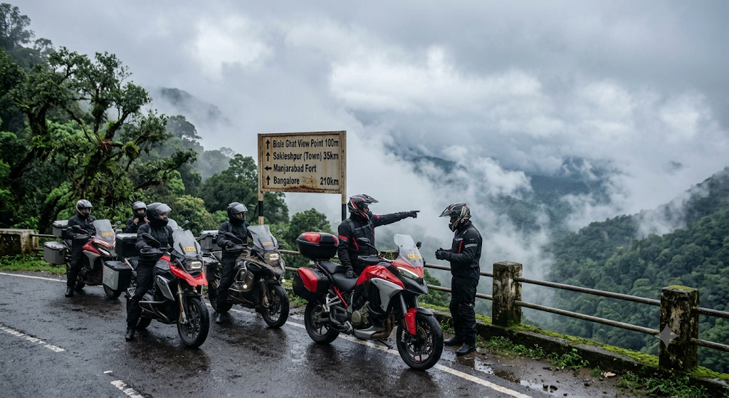
Route Introduction
Bisle Ghat is the lesser-known sibling of Charmadi Ghat — a 6 km section that crosses three valley confluences and is universally rated as Karnataka’s most beautiful monsoon road. Sakleshpur’s coffee belt makes the perfect base. Of all Bangalore-origin rides, this offers the highest scenery-to-distance ratio.
Distance | Duration
| Leg | Route | Distance | Time |
| Day 1 | Bangalore → Hassan → Sakleshpur | 220 km | 5.5 hrs |
| Day 2 | Sakleshpur → Bisle Ghat → Subramanya | 100 km | 4 hrs |
| Day 3 | Sakleshpur → Belur → Bangalore | 240 km | 6 hrs |
| Total | ~560 km |
Ride Plan (3-Day Itinerary)
Day 1 — Bangalore to Sakleshpur: 6 AM rollout via Tumkur → Hassan → Sakleshpur. Breakfast at Kunigal. Lunch at Hassan. Reach Sakleshpur by 2 PM. Visit Manjarabad Fort (star-shaped fort).
Day 2 — Bisle Ghat Day Ride: Ride to Bisle Ghat viewpoint via Hetthur. Descend to Subramanya. Lunch near Kukke Subramanya temple. Return via the same route.
Day 3 — Sakleshpur to Bangalore: Morning at a coffee estate. Lunch at Hassan. Reach Bangalore by 7 PM.
Monsoon Special Sightseeing Stops (Roadside)
· Bisle Ghat 3-valley viewpoint — official roadside deck, bikes park 5 metres away.
· Patla Betta viewpoint — mist banks visible from the road.
· Mallalli Falls roadside view — visible from the access road; no long descent needed.
· Manjarabad Fort road — star fort viewable from the parking road.
· Hetthur ghat road waterfalls — multiple flows from km 12-22.
· Donigal abandoned bridge — historic rail bridge view from the road.
Road Conditions & Riding Safety Notes (June 2026 Update)
· NH-75 Bangalore-Sakleshpur: Excellent.
· Sakleshpur-Bisle Ghat road (SH-94): Narrow but recently patched in April 2026.
· 18 km of forest road from Hetthur to Bisle Ghat has no fuel stations.
· Wild elephant crossings reported near Bisle in 2025; do not ride after 6 PM.
· Drizzle is constant — anti-fog visor is non-negotiable. Places to Stay for the Halt (Group Villas)
Places to Stay for the Halt (Group Villas)
Group Bike Trips From Delhi (Monsoon)
The Himalayan foothills 250-400 km from Delhi are surprisingly safe to ride in monsoon if you stick below 2,000 m altitude. Higher routes (Spiti, Ladakh) are dangerous in July-August. The two routes below are the safest Monsoon Group Bike Trips in India from Delhi for 2026.
Route 9: Delhi → Rishikesh → Devprayag
Route Introduction
Devprayag is where the Bhagirathi and Alaknanda merge to officially become the Ganga, and in monsoon both rivers run a furious brown. This is the most spiritual Delhi-origin monsoon ride — temples, sangam darshan, and Ganga-side cafes in Rishikesh.
Distance | Duration
| Leg | Route | Distance | Time |
| Day 1 | Delhi → Haridwar → Rishikesh | 240 km | 6 hrs |
| Day 2 | Rishikesh → Devprayag → return | 145 km | 5 hrs (loop) |
| Day 3 | Rishikesh → Haridwar → Delhi | 240 km | 6 hrs |
| Total | ~625 km |
Ride Plan (3-Day Itinerary)
Day 1 — Delhi to Rishikesh: 5 AM start via NH-334 → Muzaffarnagar → Roorkee → Haridwar. Breakfast at Cheetal Grand, Khatauli. Reach Rishikesh by 1 PM. Evening Ganga Aarti at Triveni Ghat.
Day 2 — Devprayag Day Ride: Ride to Devprayag via NH-7 along the Ganga. View the sangam, lunch at GMVN Devprayag. Return to Rishikesh by 6 PM. Beatles Ashram in the evening.
Day 3 — Rishikesh to Delhi: 6 AM start. Breakfast in Haridwar after Har Ki Pauri darshan. Lunch at Cheetal Grand. Reach Delhi by 6 PM.
Monsoon Special Sightseeing Stops (Roadside)
· Devprayag sangam viewpoint — visible from the NH-7 road railing.
· Neer Garh Waterfall roadside view — bike parks 20 metres from the falls base.
· Garud Chatti Falls road — falls visible from the access road.
· Lakshman Jhula approach road — Ganga views with roadside bike parking.
· Triveni Ghat road — Ganga aarti steps visible from the parking lane.
· Shivpuri Ganga bend — roadside Ganga rapid view, peak in August.
Road Conditions & Riding Safety Notes (June 2026 Update)
· NH-334 Delhi-Haridwar: Excellent four-lane, but heavy truck traffic.
· NH-7 Rishikesh-Devprayag: Single-lane mountain road, prone to small landslides at km 32, 48, 71.
· BRO/NHIDCL clears slides within 4-6 hours; check Twitter @NHIDCL_Ltd before riding.
· Rafting banned in monsoon — do not attempt.
· Do NOT extend to Kedarnath, Joshimath, or Badrinath in July-August.
Places to Stay for the Halt (Group Villas)
Route 10: Delhi → Lansdowne → Tehri
Route Introduction
Lansdowne is the quietest Uttarakhand hill station — no malls, no traffic, just Garhwal Rifles’ colonial cantonment and pine forests. Pair it with a ride to Tehri Dam, India’s tallest dam, and you get a low-elevation, low-rainfall safe-zone for Delhi-based groups.
Distance | Duration
| Leg | Route | Distance | Time |
| Day 1 | Delhi → Kotdwar → Lansdowne | 260 km | 7 hrs |
| Day 2 | Lansdowne → Tehri Dam → return | 220 km | 7 hrs (loop) |
| Day 3 | Lansdowne → Kotdwar → Delhi | 260 km | 7 hrs |
| Total | ~740 km |
Ride Plan (3-Day Itinerary)
Day 1 — Delhi to Lansdowne: 5 AM rollout via Meerut → Najibabad → Kotdwar → Lansdowne. Breakfast at Khatauli. Lunch at Kotdwar. Reach Lansdowne by 3 PM. Evening at Tip-N-Top viewpoint.
Day 2 — Tehri Dam Day Ride: Ride to Tehri Dam via Pauri (high-altitude detour). View the dam from Koteshwar viewpoint. Lunch at Pauri. Return to Lansdowne by 7 PM.
Day 3 — Lansdowne to Delhi: Morning at Bhulla Lake roadside. Visit Garhwali Mess regimental museum. Lunch at Kotdwar. Reach Delhi by 7 PM.
Monsoon Special Sightseeing Stops (Roadside)
· Tip-N-Top viewpoint — bike park 10 metres from the railing.
· Bhulla Lake roadside — lake visible directly from the parking lane.
· Tehri Dam Koteshwar viewpoint — dam view from the road bridge.
· Bhim Pakora roadside boulder — balancing rock photo halt.
· Pauri sunset roadside deck — Garhwal range visible without dismounting far.
· Tarkeshwar deodar forest road — temple road framed by pines.
Road Conditions & Riding Safety Notes (June 2026 Update)
· NH-119 Delhi-Najibabad: Good four-lane.
· Kotdwar-Lansdowne road (SH-9): Narrow, 41 hairpins, resurfaced March 2026.
· Lansdowne-Tehri via Pauri has 4 km of broken patches near Satpuli.
· Tehri Dam zone has security checks — carry photo ID.
· Avoid riding 7 PM-7 AM; herds of cattle on road.
Places to Stay for the Halt (Group Villas)
Group Bike Trips From Hyderabad (Monsoon)
The Deccan plateau and Eastern Ghats get a softer monsoon than the Western Ghats, with lower landslide risk. Hyderabad is one of the most underrated launch points for Monsoon Group Bike Trips in India, especially toward Andhra and Telangana hill belts
Route 11: Hyderabad → Ananthagiri Hills → Araku Valley
Route Introduction
Araku Valley sits in the Eastern Ghats and gets its highest greenery in August-September. The Ananthagiri Hills detour is a coffee-plantation belt that mirrors Coorg without the crowds. This is the longest route on our list — works best as a train-assisted ride (bikes parcel-coached overnight).
Distance | Duration
| Leg | Route | Distance | Time |
| Day 0 (Train) | Hyderabad → Visakhapatnam (Godavari Exp, bikes in parcel coach) | overnight | — |
| Day 1 | Visakhapatnam → Araku via Ananthagiri | 115 km | 5 hrs |
| Day 2 | Araku loop (Borra, Katiki, Coffee Museum) | 60 km | 4 hrs |
| Day 3 | Araku → Visakhapatnam → Train back | 115 km | 5 hrs |
| Total (ride) | ~290 km |
Ride Plan (3-Day Itinerary — Train-Assisted)
Day 0 (Night) — Hyderabad to Visakhapatnam: Board Godavari Express (12728) with bikes in parcel coach. Arrive Vizag 7 AM.
Day 1 — Vizag to Araku via Ananthagiri: Breakfast at Vizag. Ride APSH-1 to Araku via Ananthagiri Hills (coffee belt). Reach Araku by 4 PM. Evening at Padmapuram Botanical Garden roadside.
Day 2 — Araku Day: Visit Borra Caves entry road, Katiki Falls roadside view, and the Coffee Museum at Araku town.
Day 3 — Araku to Vizag, train back: Morning ride back to Vizag via Galikonda viewpoint. Lunch at Rushikonda Beach. Train to Hyderabad at night.
Monsoon Special Sightseeing Stops (Roadside)
· Ananthagiri Hills viewpoint — coffee belt views from the road’s edge.
· Galikonda viewpoint (1,643 m) — Andhra’s highest road viewpoint, bike-park right there.
· Tatipudi Reservoir lay-by — backwaters visible from NH approach.
· Borra Caves entry road — caves visible from the parking; entry on foot is short.
· Katiki Falls roadside view — visible from the road; no full trek needed.
· Chaparai cascade picnic spot — directly off the road, bikes park alongside.
Road Conditions & Riding Safety Notes (June 2026 Update)
· NH-16 Vijayawada-Vizag: Excellent four-lane.
· APSH-1 Vizag-Araku: 41 hairpins, narrow, watch for state buses.
· Borra Caves road has 6 km of broken patches.
· Mobile signal patchy in Araku valley.
· Train parcel-booking opens 7 days in advance — book at the parcel office in Secunderabad.
Places to Stay for the Halt (Group Villas)
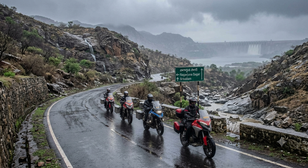
Route 12: Hyderabad → Nagarjuna Sagar → Srisailam
Route Introduction
The Krishna river forms two of South India’s biggest reservoirs at Nagarjuna Sagar and Srisailam, and both spill spectacularly in August-September. Add the Nallamala forest in between, and this becomes one of the most underrated monsoon rides in the south — most groups don’t even know it exists.
Distance | Duration
| Leg | Route | Distance | Time |
| Day 1 | Hyderabad → Nagarjuna Sagar | 165 km | 4 hrs |
| Day 2 | Nagarjuna Sagar → Srisailam via Nallamala | 155 km | 6 hrs |
| Day 3 | Srisailam → Hyderabad | 215 km | 5 hrs |
| Total | ~535 km |
Ride Plan (3-Day Itinerary)
Day 1 — Hyderabad to Nagarjuna Sagar: 7 AM start via NH-65 → Miryalaguda → Nagarjuna Sagar. Breakfast at Choutuppal. Reach Nagarjuna Sagar by 1 PM. Visit dam viewpoint.
Day 2 — Nagarjuna Sagar to Srisailam: Ride via Mannanur through Nallamala Tiger Reserve. No food stops in forest (eat at Mannanur). Reach Srisailam by 3 PM. Evening at Mallikarjuna Jyotirlinga.
Day 3 — Srisailam to Hyderabad: Sunrise at Pathala Ganga ropeway road. Lunch at Mahbubnagar. Reach Hyderabad by 6 PM.
Monsoon Special Sightseeing Stops (Roadside)
· Nagarjuna Sagar Dam roadside view — view from the road; photography restricted at gates.
· Ethipothala Falls — visible from the access road, bike parks 30 metres away.
· Nallamala forest waterfalls — multiple unnamed roadside flows in August.
· Srisailam Dam gate view — roadside view when gates open (884 ft mark).
· Pathala Ganga ropeway top — viewable from the roadside parking.
· Mannanur forest checkpoint clearing — open canopy view of Nallamala.
Road Conditions & Riding Safety Notes (June 2026 Update)
· NH-65 Hyderabad-Miryalaguda: Good two-lane.
· Nallamala forest road (NH-765): Tiger reserve, rides allowed only 6 AM-6 PM.
· Forest checkpoint at Mannanur — declare group size, no overnight halts permitted in forest.
· 14 km of broken patches between Achampet and Mannanur.
· Network is dead for 60 km inside the forest.
Places to Stay for the Halt (Group Villas)
Group Bike Trips From Chennai (Monsoon)
Tamil Nadu’s monsoon arrives later — the northeast monsoon peaks October-December — so July-September is mild rain ideal for riding. The route below is the best of the Monsoon Group Bike Trips in India for Chennai-based groups.
Route 13: Chennai → Yelagiri → Yercaud
Route Introduction
Yelagiri and Yercaud are two compact hill stations within 350 km of Chennai, both at around 1,400 m elevation. The southwest monsoon brings moderate rainfall — enough for waterfalls and greenery, not enough to flood ghats. This is the lowest-risk entry point for first-time monsoon riders in the south.
Distance | Duration
| Leg | Route | Distance | Time |
| Day 1 | Chennai → Vellore → Yelagiri | 235 km | 5 hrs |
| Day 2 | Yelagiri → Salem → Yercaud | 175 km | 5 hrs |
| Day 3 | Yercaud → Chennai | 360 km | 8 hrs |
| Total | ~770 km |
Ride Plan (3-Day Itinerary)
Day 1 — Chennai to Yelagiri: 6 AM rollout via NH-48 → Vellore → Yelagiri. Lunch at Vellore. Reach Yelagiri by 3 PM. Evening at Punganur Lake.
Day 2 — Yelagiri to Yercaud: Descend Yelagiri, ride to Salem via NH-44, climb Yercaud via SH-180. Reach by 3 PM. Evening at Yercaud Lake.
Day 3 — Yercaud to Chennai: 6 AM start. Descend Yercaud via 20 hairpins. Lunch at Krishnagiri. Reach Chennai by 5 PM via NH-48.
Monsoon Special Sightseeing Stops (Roadside)
· Punganur Lake, Yelagiri — directly off the road; bike parks lakeside.
· Jalagamparai Falls roadside view — falls visible from the road approach.
· Yercaud Lake — bike park on the lake-front road.
· Pagoda Point, Yercaud — viewpoint with road-edge bike parking.
· Lady’s Seat misty cliffs — bike park 10 metres from the viewpoint.
· Anchetty road waterfalls — multiple flows on the Yelagiri-Hosur ghat road.
Road Conditions & Riding Safety Notes (June 2026 Update)
· NH-48 Chennai-Vellore: Excellent.
· Yelagiri 14 hairpins (SH-128): Resurfaced February 2026.
· Salem-Yercaud (SH-180): 20 hairpins, very tight curves at km 8-12.
· Yercaud-Salem morning fog (6-8 AM); ride after 9 AM downhill.
· Carry photocopy of license + RC + insurance; checkpoints active.
Places to Stay for the Halt (Group Villas)
Group Bike Trips From Ahmedabad (Monsoon)
Gujarat’s only hill station is Saputara, a 4-hour ride into the Western Ghats. For Ahmedabad-based groups looking at Monsoon Group Bike Trips in India, this is the most accessible Sahyadri taste.
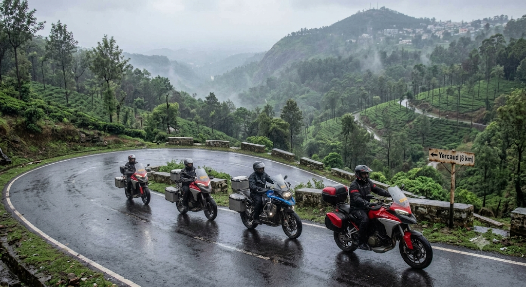
Route 14: Ahmedabad → Saputara → Don Hill Station
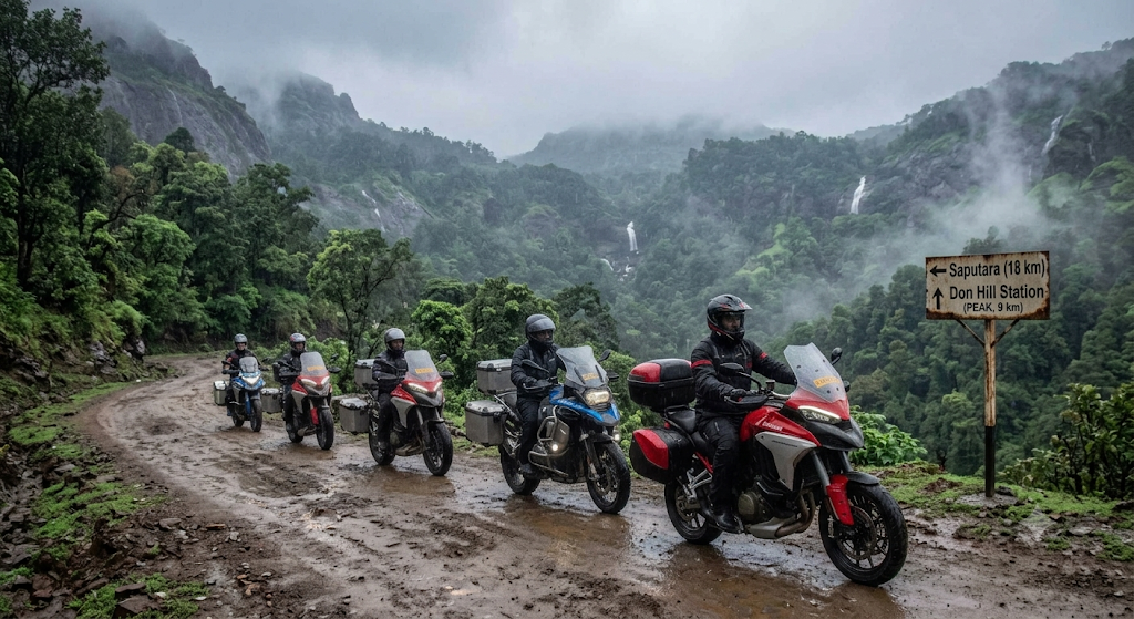
Route Introduction
Saputara sits at 1,000 m on the Maharashtra-Gujarat border in the Dang district. Pair it with Don Hill Station (the actual highest point in the Dang) for a quieter alternative to crowded Saputara viewpoints. This is the best ride for Gujarati groups who want lush ghats without the long haul to Mahabaleshwar.
Distance | Duration
| Leg | Route | Distance | Time |
| Day 1 | Ahmedabad → Surat → Saputara | 410 km | 8 hrs |
| Day 2 | Saputara → Don Hill → return | 80 km | 4 hrs (loop) |
| Day 3 | Saputara → Ahmedabad | 410 km | 8 hrs |
| Total | ~900 km |
Ride Plan (3-Day Itinerary)
Day 1 — Ahmedabad to Saputara: 5 AM start via NH-48 → Vadodara → Surat → Vyara → Waghai → Saputara. Breakfast at Vadodara. Lunch at Surat. Reach Saputara by 4 PM. Evening at Sunset Point.
Day 2 — Saputara to Don Hill: Ride to Don Hill via Gadhvi. Roadside tribal village photo halt. Picnic lunch. Return to Saputara via Mahal eco-camp.
Day 3 — Saputara to Ahmedabad: 5 AM start. Breakfast at Vyara. Lunch at Surat. Reach Ahmedabad by 6 PM.
Monsoon Special Sightseeing Stops (Roadside)
· Sunset Point, Saputara — bike park 5 metres from the viewing rail.
· Saputara Lake roadside — lake directly off the road.
· Gira Falls, Waghai — visible from the road bridge; no long walk required.
· Girmal Falls roadside view — Gujarat’s highest, visible from the access road.
· Mahal eco-campsite stream — stream visible directly from the parking road.
· Don Hill viewpoint — peak view from the roadside parking pad.
Road Conditions & Riding Safety Notes (June 2026 Update)
· NH-48 Ahmedabad-Surat: Excellent six-lane.
· Surat-Vyara (NH-953): Resurfaced January 2026.
· Vyara-Saputara has 18 hairpins; ride single file.
· Saputara internal roads slippery from moss; helmet visor anti-fog mandatory.
· Toll plazas on NH-48 — keep FASTag balance.
At-a-Glance Route Comparison
| # | Route | From | Total km | Difficulty | Best Month |
| 1 | Tamhini → Kashid | Mumbai | 370 | Beginner | July |
| 2 | Malshej → Igatpuri | Mumbai | 450 | Intermediate | August |
| 3 | Lonavala → Bhandardara | Mumbai | 540 | Advanced | August |
| 4 | Mahabaleshwar → Tapola | Pune | 315 | Beginner | July |
| 5 | Bhimashankar → Malshej | Pune | 390 | Intermediate | August |
| 6 | Coorg → Abbey Falls | Bangalore | 595 | Intermediate | August |
| 7 | Chikmagalur → Mullayanagiri | Bangalore | 570 | Advanced | September |
| 8 | Sakleshpur → Bisle Ghat | Bangalore | 560 | Intermediate | August |
| 9 | Rishikesh → Devprayag | Delhi | 625 | Intermediate | August |
| 10 | Lansdowne → Tehri | Delhi | 740 | Advanced | August |
| 11 | Ananthagiri → Araku | Hyderabad | 290 (ride) | Advanced | September |
| 12 | Nagarjuna Sagar → Srisailam | Hyderabad | 535 | Intermediate | August |
| 13 | Yelagiri → Yercaud | Chennai | 770 | Beginner | September |
| 14 | Saputara → Don Hill | Ahmedabad | 900 | Intermediate | August |
Planning Tips for Monsoon Group Bike Trips in India
Group size and formation
Limit groups to 8-12 riders. Larger groups stretch across ghats and lose sight of each other in mist. Assign a Lead (most experienced), Sweeper (mechanically inclined), and a Mid-pack rider with the first-aid kit.
Documentation checklist
Carry physical and digital copies of license, RC, PUC, insurance, and helmet certification. Several states (Maharashtra, Karnataka, Tamil Nadu) have stepped up monsoon checkposts in 2026.
Insurance and emergency
Ensure all riders have personal accident cover (minimum ₹15 lakh) and zero-dep bike insurance. Save the emergency numbers: 112 (national emergency), 1033 (highway helpline), 108 (ambulance).
What to skip in monsoon
Skip Spiti, Ladakh, Sach Pass, Killar-Kishtwar, Sandakphu, Munsiyari, and any route above 2,500 m between July and August. Landslide risk is too high. These often appear on monsoon riding lists, but the safety record says otherwise.
Booking lead time
Book group villas 4-6 weeks ahead for August weekends. Coorg, Mahabaleshwar, Lansdowne, Igatpuri, and Sakleshpur sell out fastest.
Packing Guide for Monsoon Group Bike Trips in India
A tight packing list, organised by riding kit, personal essentials, group kit, and bike spares. Pack on the bike (saddle bags + tank bag), never a backpack — wet backpacks ruin posture and grip.
Riding Kit (On the Rider)
| Item | Why |
| Full-face helmet with anti-fog visor | Non-negotiable for monsoon visibility |
| Waterproof + breathable riding jacket (CE-rated) | Stops chill at 18°C ghat sections |
| Waterproof riding pants or rain over-pants | Jeans get heavy in 10 minutes of rain |
| Mesh + waterproof riding gloves (two pairs) | One wet pair, one dry pair |
| Waterproof riding boots (ankle protection) | Sneakers + flip-flops are a hospital ticket |
| Knee guards (worn under pants) | Wet roads = more low-speed slides |
| Buff or neck warmer | Cold rain on the throat causes fatigue |
Personal Essentials (Tank Bag)
| Item | Notes |
| Microfibre cloth (2-3) | For visor wiping mid-ride |
| Anti-fog spray | One small can per group |
| Spare contact lenses / glasses | Rain ruins both, fast |
| Phone in waterproof pouch | Even “splash-proof” phones die in 30 mins of rain |
| Power bank (10,000 mAh+) | Charging stops are limited |
| Cash (₹3,000-₹5,000) | UPI fails in poor-network ghats |
| Original + photocopies — License, RC, PUC, insurance | Two sets each |
| Group host / hotel address printed | Phone dies, paper doesn’t |
Personal Essentials (Saddle Bag — Waterproof Inner)
| Item | Notes |
| 3 sets quick-dry tees + 2 trekking trousers | Cotton stays wet for hours |
| 5 sets socks + 5 sets innerwear | Wet socks = blisters in 2 hours |
| Flip-flops + a pair of villa slippers | For wet-shoes-off arrival |
| Compact toiletry kit | Tube toothpaste, soap bar, deodorant |
| Personal medications | In a zip-lock bag |
| Quick-dry towel (microfibre) | Cotton towels never dry |
| Sleepwear | One warm set |
Group Kit (Split Across the Group)
| Item | Carry count |
| Comprehensive first-aid kit | 1 per group |
| Bluetooth intercoms (Cardo/Sena) | 1 per rider |
| GoPro or action cam | 1-2 per group |
| Tow rope (4 metres, 5,000 kg load) | 1 per group |
| Multi-tool with screwdriver heads | 2 per group |
| Tubeless tyre puncture kit + 5 plug-strings | 2 per group |
| Portable air pump (12V) | 1 per group |
| Snake-bite kit | 1 per group (forest routes) |
| Glucose sachets + ORS sachets | 4 per rider |
| Energy bars / dry fruits | 2 days of buffer |
| Disposable rain ponchos (emergency) | 2 spare per group |
| Spare bike key (with sweeper) | 1 per bike |
Bike Spares (Sweeper Carries)
| Item | Why |
| Spare clutch + brake lever | Cheap, replaces in 5 minutes after a fall |
| Spare bulbs (headlight + tail) | Vibration kills bulbs |
| Master link for chain | Chain breaks happen |
| Wax-based chain lube | WD-40 washes off in rain |
| Spare spark plug | Wet ignition fix |
| Bungee cords (4) | For luggage re-strap |
| Insulation tape + duct tape | Universal fix |
| Owner’s manual (printed) | For ECU error codes |
Documents (Every Rider, Two Copies — Wet + Dry Bag)
· Driving license
· Bike Registration Certificate (RC)
· Pollution Under Control (PUC) certificate
· Insurance certificate
· ID proof (Aadhaar / passport copy)
· Group itinerary with villa addresses
· Emergency contact list
Pro tip: Vacuum-seal all documents in zip-lock bags before packing them in the tank bag. We’ve seen plastic-folder “waterproof” sleeves leak after 4 hours of heavy rain.
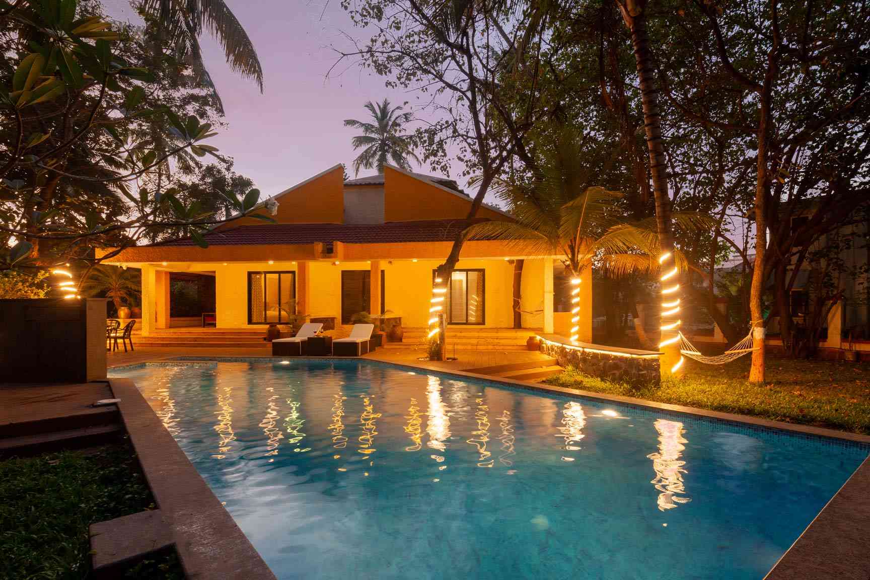
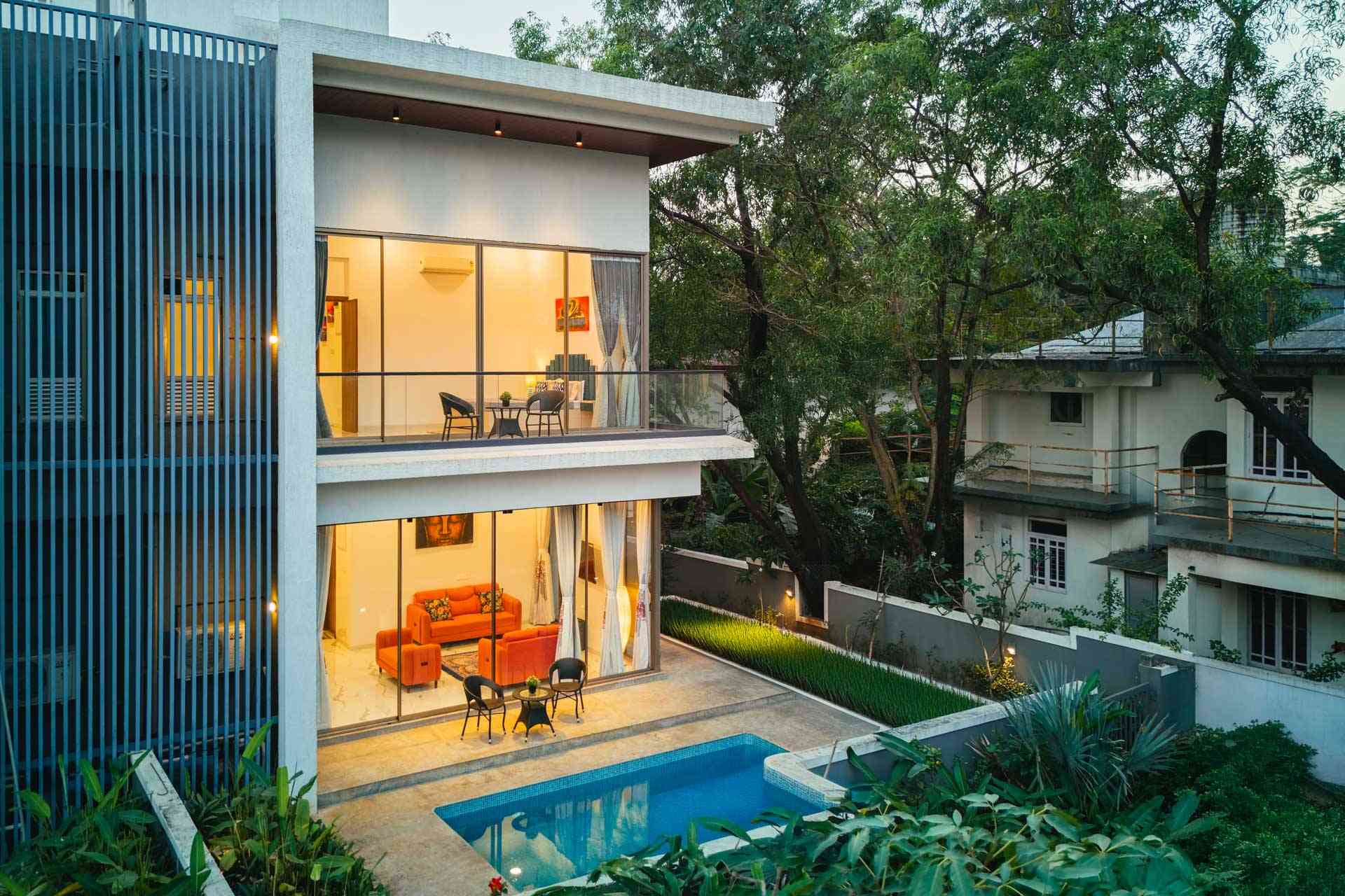
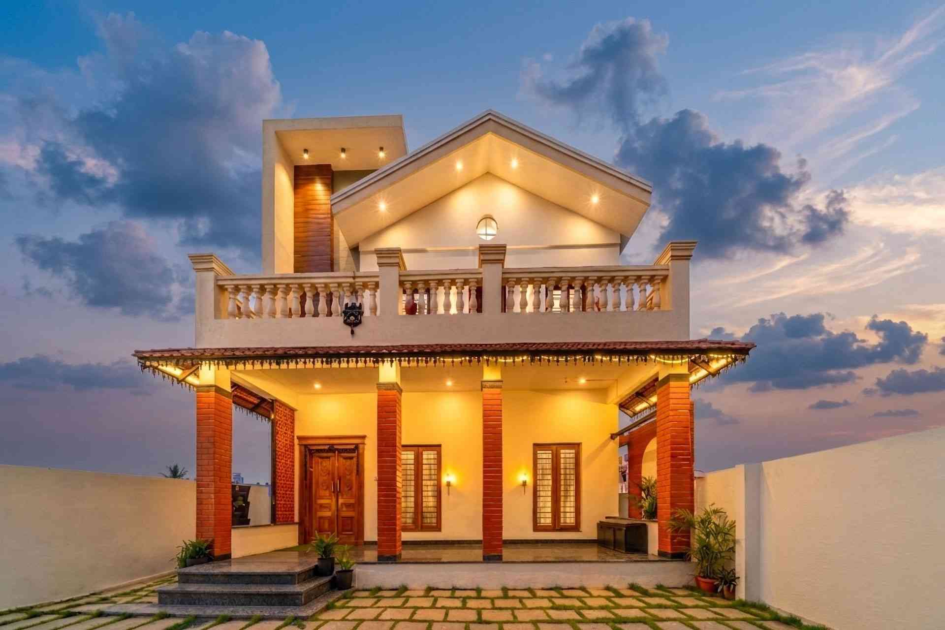
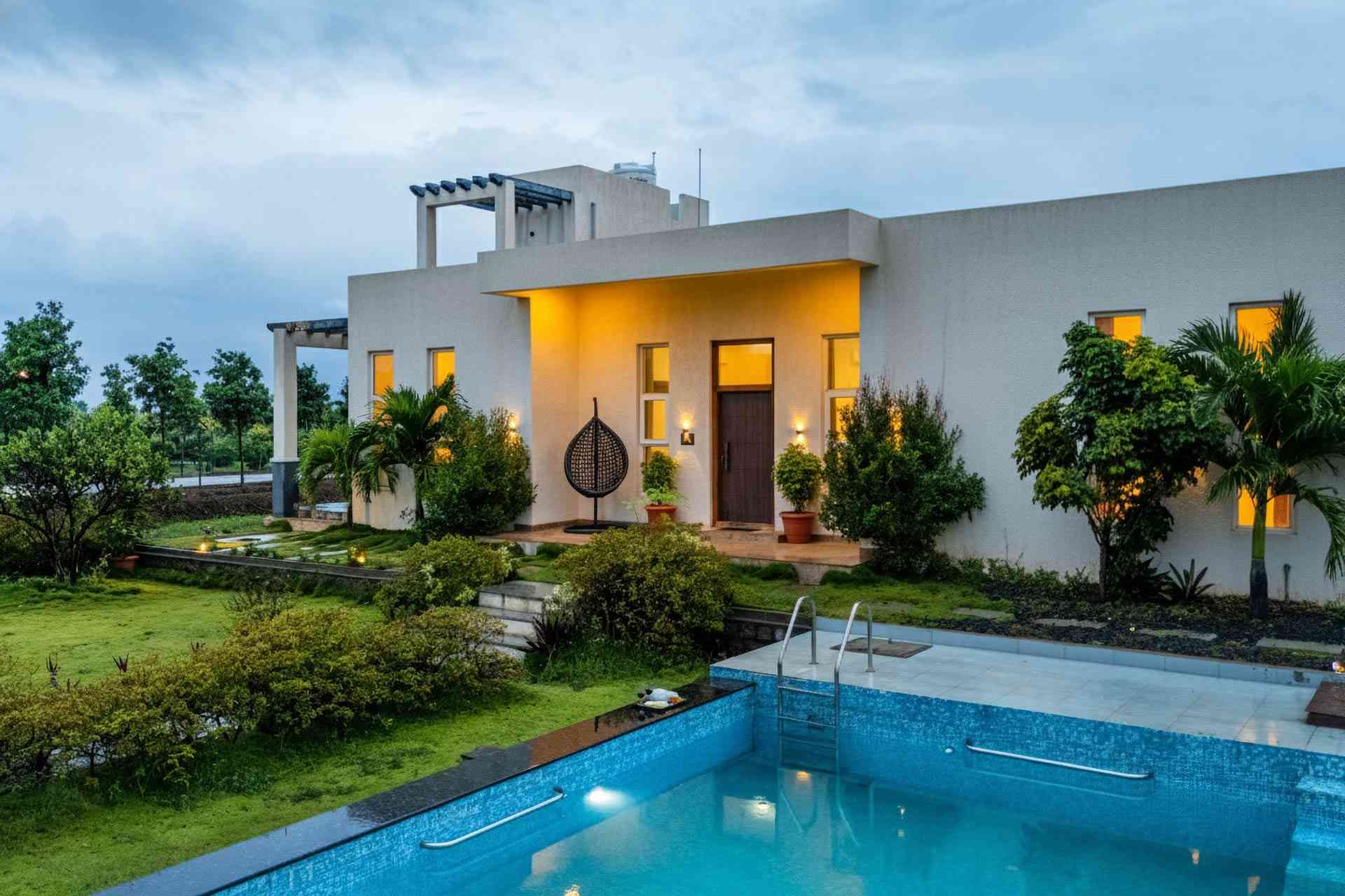
Where to Stay: Group Villas for Bike Trips
After 8 hours on wet ghats, the difference between a generic hotel and a well-equipped group villa is everything. For these rides, we recommend StayVista group villas because they offer:
· Covered parking for 6-12 bikes (not exposed lots)
· Drying area for riding gear (jackets, gloves, boots)
· Private chef option with hot meals after late arrivals
· Larger common areas for trip debriefs and route planning
· Verified properties with on-call hosts for emergencies
Bike-trip-friendly StayVista destinations: Lonavala, Kolad, Alibaug, Mahabaleshwar, Panchgani, Igatpuri, Bhandardara, Coorg, Chikmagalur, Sakleshpur, Rishikesh, Lansdowne, Saputara.
Where to book: Browse StayVista’s group villa collection at stayvista.com and filter by 8+ guests, secure parking, and private chef.
Conclusion: Your 2026 Monsoon Riding Season
The 14 routes above cover every major rider hotspot in India and span 8,000+ km of ghat, coast, plateau, and foothill terrain. Whether you’re a Mumbai group eyeing Tamhini Ghat for the first time or a Hyderabad crew planning the long haul to Araku, the monsoon window between mid-July and mid-September 2026 is yours to claim. Pick a route, prep the bike, prep the gear, and ride safe — these Monsoon Group Bike Trips in India are best done slow, in a tight group, and with a great villa waiting at the end of each day.
Book your group villa for the 2026 monsoon at stayvista.com.
Frequently Asked Questions
Yes, if you stick to routes below 2,000 m altitude in the Western Ghats, Eastern Ghats, and Himalayan foothills below Joshimath. Avoid Spiti, Ladakh, Sach Pass, and Killar-Kishtwar between July and August due to landslides. All 14 routes in this guide are vetted for monsoon safety.
Mid-July to mid-September is the sweet spot. June is risky because of fresh landslides; October sees the monsoon retreat. August is peak greenery and peak waterfall flow, especially in the Western Ghats.
Mumbai → Tamhini Ghat → Kashid (370 km loop) is the easiest. The ghat section is short, traffic is moderate on weekdays, and the route avoids high-altitude passes.
Waterproof riding jacket, anti-fog visor, mesh gloves, knee guards, full-face helmet, rain cover for luggage, microfibre cloth, and wax-based chain lube. Tubeless tyres with at least 2 mm tread depth are non-negotiable.
Visit stayvista.com, filter by destination and group size (8+ guests), and look for properties tagged with covered parking and gear-drying facilities. Book 4-6 weeks ahead for August weekends, especially in Coorg, Mahabaleshwar, and Lansdowne.
Adventure tourers like the Royal Enfield Himalayan 450, Triumph Tiger 400, KTM 390 Adventure, and Kawasaki Versys 650 are ideal. They offer better ground clearance, knobby tyres, and upright seating for long ghat rides. Avoid heavily-faired sports bikes.
No. Both regions become extremely dangerous between July and August due to flash floods, washed-out bridges, and landslides. Ladakh’s safe window is May-June and September. Spiti is best in May-June or October.
Refuel at 50% tank in ghat sections. Petrol stations are sparse in Tamhini Ghat, Bisle Ghat, Nallamala forest, and Yercaud descents. Plan refuels at the start and end of every ghat section.
Yes. Maharashtra, Karnataka, Tamil Nadu, and Uttarakhand have increased highway checkposts in monsoon 2026 due to spike in accidents. Carry physical and digital copies of license, RC, PUC, and insurance.
At least 5,000 km of total ride experience and 500 km of wet-weather riding. First-time monsoon riders should pick Beginner-tier routes (Tamhini, Mahabaleshwar, Yelagiri) and stick to groups led by experienced sweepers.