Komic, Hikkim & Langza: Inside the World’s Highest Village Cluster in Spiti (2026 Guide)
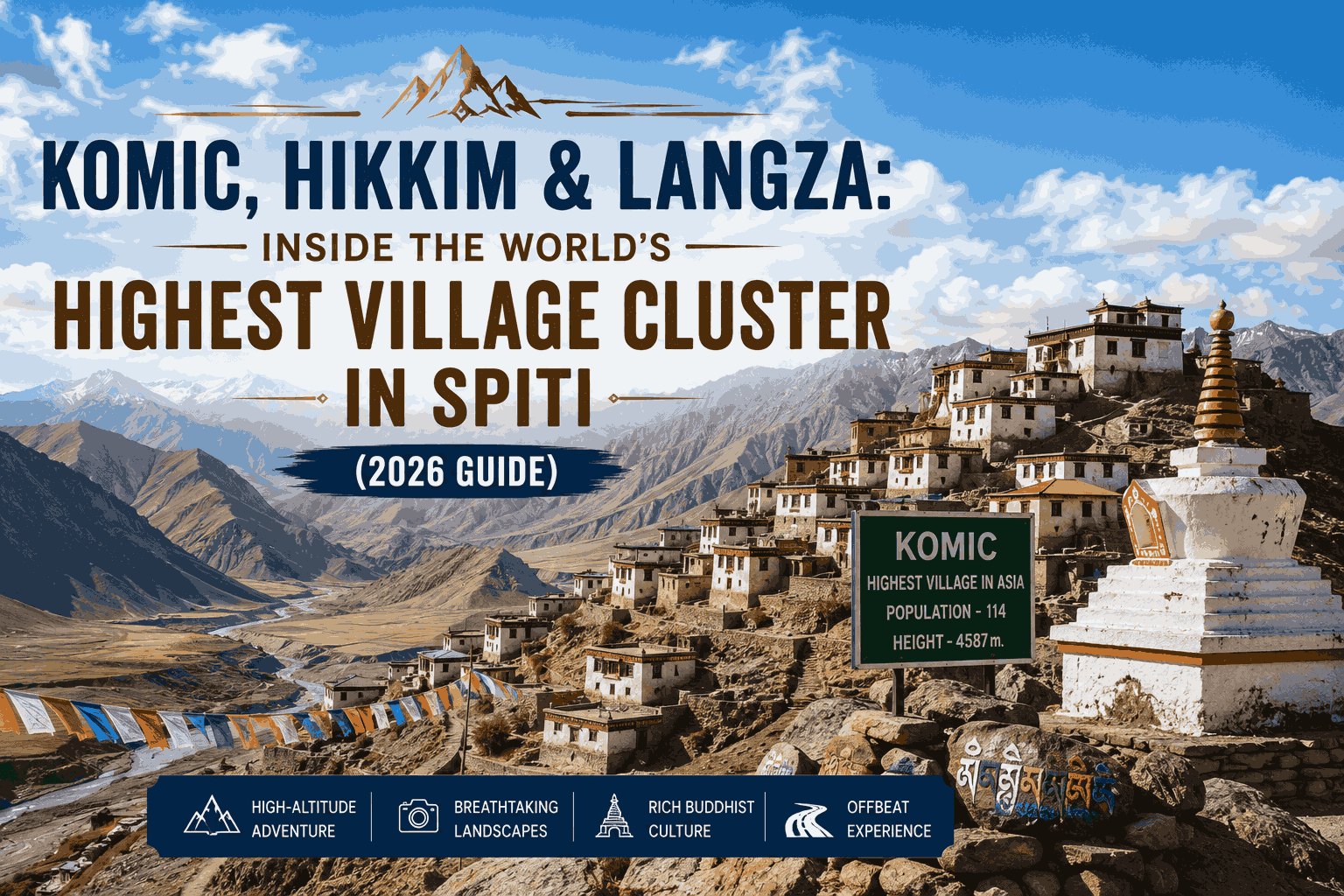
On one 44-kilometre loop above Kaza, you can mail a postcard from the world’s highest post office, stand in one of the highest villages anywhere reachable by car, and pick up a 200-million-year-old seashell from what used to be an ocean floor. All before lunch. Komic, Hikkim and Langza sit within a short drive of each other in Spiti Valley, and together they pack more record-breaking trivia into one morning than most Himalayan trips manage in a week.
Here’s the catch most guides skip: this little loop is also the highest-altitude day of your entire Spiti journey. Get the planning right — especially the acclimatisation — and it’s unforgettable. Get it wrong and you’ll spend it nursing a headache at 4,500 metres. This is the June-2026 deep-dive on all three villages, with verified distances, honest claims and the practical detail you actually need.
Komic (4,587 m), Hikkim (4,400 m) and Langza (4,420 m) form a ~44 km day-trip loop from Kaza — home to one of the world’s highest motorable villages, the world’s highest post office (running since 1983), and ~200-million-year-old Tethys Sea fossils. June is the season opener: both routes are open and days hit 15–20°C. But the cluster sits above 4,400 m, where altitude sickness affects roughly 1 in 4 visitors (NIH/PMC) — acclimatise in Kaza first.
In this Blog
Where are Komic, Hikkim and Langza?
The three villages sit 14–19 km from Kaza (3,650 m), the main town of Spiti Valley in Himachal Pradesh, and together form a loop of roughly 44 km you can drive in a single day. They’re clustered on the high plateau south-east of Kaza, which is exactly why travellers tackle them as one outing rather than three separate trips.
Why group them? Because they share the same high-altitude shelf, the same barren, moon-like terrain, and the same road. Langza, Komic and Hikkim are strung along one circuit that climbs off the valley floor and loops back. This is also the highest leg of any Spiti itinerary — you’ll gain nearly 1,000 metres above Kaza in the space of a morning. That matters more than the scenery, and we’ll come back to it.
Altitude of the Spiti village cluster (metres)
To orient yourself: Kaza is your base, with the only fuel, ATM and proper hotels. From there a single road climbs to Langza, traverses to Komic and Hikkim, and drops back to Kaza. For the full route into the valley itself — Manali side or Shimla–Kinnaur side — see our guide on how to reach Spiti via the Shimla–Kinnaur or Manali route.
Source: Wikipedia village infoboxes (Komic, Hikkim, Langza, Kaza, Kunzum Pass, Tangyud Monastery), 2026.
Is Komic really the world’s highest village?
Komic sits at 4,587 m (15,049 ft) and is best described as one of the world’s highest villages connected by a motorable road — not the undisputed highest on Earth. That precise wording matters. The bolder “highest village in the world” claim comes from the village signboard and gets repeated everywhere, but higher inhabited settlements exist, such as La Rinconada in Peru at around 5,100 m.
So is the sign lying? Not exactly. Komic has a strong claim to being among the highest villages you can actually drive to, with a metalled road and a year-round population. Wikipedia hedges it to “one of the world’s highest,” and that’s the honest version. We’d rather you arrive knowing the real story than parroting a slogan.
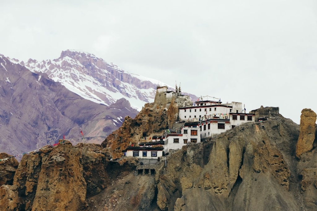
The village itself is tiny — a population of 130 at the 2011 Census — and centred on Tangyud Monastery (also called Komic Gompa), perched at about 4,520 m and counted among the highest gompas in India. The whitewashed complex, with its red-ochre fort-like walls, is the reason most people climb up here beyond the bragging rights.
Komic, in Spiti Valley, stands at 4,587 m (15,049 ft) and is regarded as one of the world’s highest villages reachable by a motorable road, according to Wikipedia. With a population of just 130 and the cliff-top Tangyud Monastery at its heart, it is a genuine record-holder for road access — though not the single highest inhabited place on the planet.
Komic — quick practical details
| Detail | Information |
| Altitude | 4,587 m (15,049 ft) |
| Entry fee | Free (small donation customary inside Tangyud Monastery) |
| Timings | Village open all day; monastery roughly 7:00 AM–7:00 PM |
| Best time to visit | June to September; mornings for clear light |
| How to reach | ~18–19 km from Kaza via Hikkim (~60–90 min drive) |
| Time required | 45–60 minutes |
| Ideal for | Monastery lovers, photographers, record-chasers |
| Pro tip | Walk slowly here — it’s the highest point of your day; let the engine, not your lungs, do the climbing |
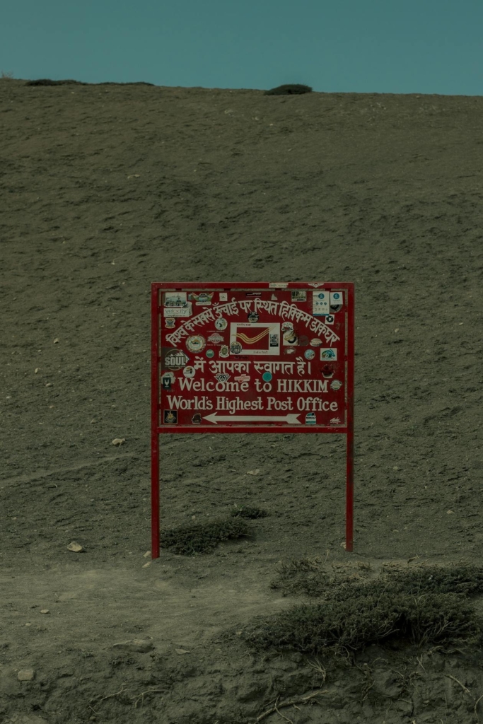
Hikkim — the world’s highest post office
At 4,400 m (14,400 ft), Hikkim runs what’s billed as the world’s highest post office — and it has done so since 1983. The branch operates under postmaster Rinchen Chhering, who has run it since it opened, carries the pincode 172114, and doubles as a small savings bank for the surrounding hamlets (Wikipedia).
The ritual here is simple and oddly moving. You buy a postcard, write it at 4,400 metres, and post it to someone back home — who receives, weeks later, a card that travelled by hand from one of the most remote letterboxes on Earth. There’s no conveyor belt and no van. Mail is carried on foot down to Kaza before it joins the regular postal network.
Don’t expect a grand building. The post office is a modest room in a mud-brick house, and in deep winter it shuts under snow. Carry your own pen, a few addresses written out in advance, and small cash — there’s no card machine at the roof of the world.
From the road: when our team posted cards here, the postmaster stamped each one by hand and we still had them beat us home by a fortnight. Write your cards the night before in Kaza — at 4,400 m, fingers get clumsy and the queue is small but slow.
Hikkim — quick practical details
| Detail | Information |
| Altitude | 4,400 m (14,400 ft) |
| Entry fee | Free; postcard + stamp roughly ₹30–50 |
| Timings | Roughly 10:00 AM–4:00 PM, Mon–Sat; closed Sundays and in heavy winter snow |
| Best time to visit | June to early October (post office shuts when snowbound) |
| How to reach | ~15–16 km from Kaza (~45 min); 3 km from Komic |
| Time required | 30–45 minutes |
| Ideal for | Souvenir-hunters, families, anyone who loves a story |
| Pro tip | Buy a few extra postcards as keepsakes — they sell out by mid-season |
Langza — fossils, a giant Buddha and the Tethys Sea
Langza (4,420 m) is famous for two unlikely things at 14,500 feet: marine fossils and a giant Buddha. The slopes around the village hold ammonites — coiled shells of sea creatures roughly 200 million years old — left behind by the ancient Tethys Sea that covered this land before the Himalayas rose (Wikipedia).
Let that sink in. You’re standing higher than most mountains in Europe, holding a fossil from an ocean floor. The geology is the real headline: this whole region was seabed until the Indian and Eurasian plates collided and pushed it skyward. Local children often offer fossils to visitors, but collecting them is increasingly discouraged — photograph them, admire them, and leave them on the mountain.
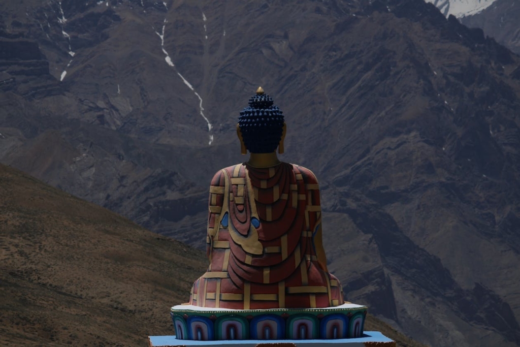
Above the village sits the much-photographed golden Buddha, gazing out over the valley. One honest correction: despite what many blogs claim, this statue is a modern construction (around 2005), not a 1,000-year-old relic. The genuinely old structure is the small Lang Temple behind it. Langza had 136 residents at the 2011 Census, and is also known for traditional Zama pottery and grazing yaks.
The Langza Buddha statue, a seated golden figure overlooking the village at 4,420 m, is a contemporary build from roughly 2005 — not an ancient monument, contrary to popular travel lore. What is ancient here are the Tethys Sea fossils on the surrounding slopes, dated to about 200 million years, making Langza a rare spot to touch deep geological time.
Langza — quick practical details
| Detail | Information |
| Altitude | 4,420 m (~14,500 ft) |
| Entry fee | Free |
| Timings | Open all day; daylight hours best for fossil walks |
| Best time to visit | June to September; clear nights are superb for stargazing |
| How to reach | ~14–15 km from Kaza (~45 min) |
| Time required | 1–1.5 hours |
| Ideal for | Families, geology buffs, astrophotographers |
| Pro tip | Look but don’t loot — photograph fossils and leave them; carrying them out is now frowned upon and harms the site |
How to drive the Langza–Komic–Hikkim loop
The full loop from Kaza is roughly 44 km and fits comfortably into a single morning-to-afternoon outing — about 3–4 hours of actual driving, or 5–7 hours with village stops. The standard order is Kaza → Langza → Komic → Hikkim → back to Kaza, though you can run it in reverse; the distance is identical either way.
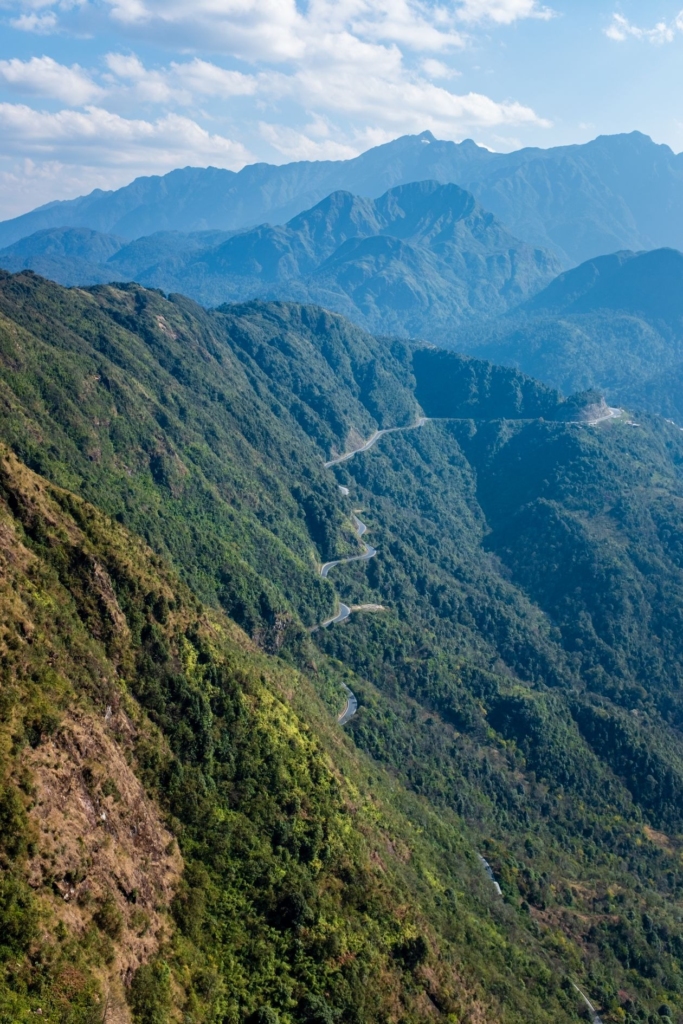
Tank up and stock up in Kaza, because there’s nothing on the loop. No fuel, no ATM, and effectively no mobile signal — only BSNL works intermittently up here, and mostly it doesn’t. The road is paved in stretches and rough gravel in others, manageable in a hatchback driven carefully, though a higher-clearance vehicle is more comfortable.
The Langza–Komic–Hikkim circuit is about 44 km round-trip from Kaza, with verified legs of roughly 15 km (Kaza–Langza), 10 km (Langza–Komic), 3 km (Komic–Hikkim) and 15 km (Hikkim–Kaza). Start early, carry water and snacks, and budget a full half-day so you can linger at each village rather than racing the loop.
What to carry for the loop
Because there’s no signal, no fuel and no shop once you leave Kaza, a little prep saves the day. Pack these before you set off:
- Cash — homestays, tea stalls and postcards are cash-only; the nearest ATM is in Kaza.
- A full tank — fuel up at the Indian Oil pump in Kaza, billed as the world’s highest petrol pump at 3,740 m, with no fuel anywhere on the loop.
- Layers — June mornings are cold even when afternoons feel warm; the wind at 4,500 m has a bite.
- Water and snacks — staying hydrated genuinely helps with the altitude.
- Strong sunscreen and sunglasses — UV is fierce at this elevation, and the high sun reflects off bare rock.
Start the loop by mid-morning so you’re not driving the rough sections in fading light. A small first-aid kit and any altitude medication your doctor has advised round out the list.
Spiti in June — is the village cluster open?
Yes — June is one of the best windows for the cluster. By then both access routes are open: the Shimla–Kinnaur road stays drivable year-round, and the Manali route over Kunzum Pass (4,551 m) typically opens between late May and mid-June once the snow clears. June days run a pleasant 15–20°C, nights hover near freezing, and the skies are mostly clear and dry.
One early-season caveat: roads in June can still be rough where winter and spring runoff have chewed up the surface, and repairs aren’t always finished. Check current conditions before you commit to a date — the official Lahaul & Spiti district road-status page is the most reliable source. Chandratal usually becomes accessible by mid-June once Kunzum Pass opens fully.
Which route should you pick? The Shimla–Kinnaur approach gains height gradually over several days, which helps your body acclimatise — a genuine advantage before tackling a 4,500 m village loop. The Manali route is faster but climbs hard and fast, raising altitude-sickness risk. For a full breakdown, see our route and permits guide, and for the wider circuit, our complete Spiti Valley travel guide. Travelling in the cold months instead? Our winter Spiti guide covers December.
By June, the Manali–Kunzum Pass route into Spiti is usually open, joining the year-round Shimla–Kinnaur road, with daytime temperatures around 15–20°C. That makes the Komic–Hikkim–Langza loop fully accessible — though early-June road surfaces can be rough, so checking the official district road-status page before travel is essential.
Altitude sickness — why this is Spiti’s highest day
The entire cluster sits above 4,400 m, which makes it the single highest-altitude day of most Spiti trips — and the one where acute mountain sickness (AMS) is most likely to bite. Research published via the NIH shows AMS can affect travellers above 2,500 m, with roughly 1 in 4 people developing symptoms by about 3,500 m (NIH/PMC, 2021).
What does that mean in practice? Spend at least a day acclimatising in Kaza (3,650 m) before you climb to Komic. Watch for headache, nausea, dizziness and breathlessness. If symptoms get worse as you go higher, the only reliable fix is to descend. Drink plenty of water, skip alcohol the night before, and don’t treat the loop as a race.
Because the cluster sits in the 4,400–4,587 m band, AMS risk is materially higher here than on the valley floor: NIH data records symptom rates climbing from around 27% at 3,500 m toward 73% by 5,300 m. The nearest medical help is the Community Health Centre in Kaza, so the safe play is to acclimatise low, ascend slowly, and turn back if anyone in your group struggles.
Where to stay — homestays in the cluster and StayVista bookends in Shimla and Manali
Inside the villages, accommodation means basic, warm-hearted homestays in Langza, Komic and Hikkim — typically ₹800–1,500 per person including home-cooked meals. Expect mud-brick rooms, shared bathrooms, no signal and limited power. Most travellers instead base in Kaza, then bookend the high-altitude leg with a comfortable stay in their gateway town to rest and acclimatise. That’s where StayVista comes in.
If you’re entering via the Shimla–Kinnaur route, stay a night before the climb:
Ved Vilas — an elegant Mashobra villa with sweeping valley views, a balcony jacuzzi and bonfire. A calm first-night base for couples and small families.
The Theog Altair — a hilltop retreat in Theog that sits right on NH-5, the Shimla–Kinnaur–Spiti road, so it’s a genuine head-start before Sarahan and Kalpa. It flexes from 3 to 7 bedrooms, with a Mehrab-style entrance, mountain views, evening bonfire and BBQ. Our pick for the Shimla side, simply because it’s on the route.
Rose Cottage — a heritage colonial home about 4 km from Mall Road, with vintage wood interiors and big-group capacity. Ideal for large convoys staging together before Spiti.

If you’re entering via the Manali route over the Atal Tunnel and Kunzum Pass:
- Casa Bella Vista — a 6BHK villa in central Manali near Mall Road, with a swimming pool and hammocks. The most convenient bookend to stock up before the Atal Tunnel, or to celebrate after exiting via Kunzum La. Our pick for the Manali side.
- The WaterWillow — a green retreat with uninterrupted Pir Panjal and Dhauladhar views, well suited to couples and families.
- The Imperial Estate — a heritage palace-style property in Naggar on the Kullu–Manali road, with suite-style rooms for up to 15 guests. A grand gathering point for very large groups assembling for the Spiti push.


Frequently Asked Questions
Komic in Spiti (4,587 m / 15,049 ft) is widely described as one of the highest villages connected by a motorable road, per Wikipedia. It isn’t the undisputed global highest — higher inhabited settlements exist, such as La Rinconada in Peru at about 5,100 m.
Komic, at 4,587 m in Spiti Valley, Himachal Pradesh, is regarded as India’s highest village reachable by a motorable road. It has a population of around 130 and is home to Tangyud Monastery at roughly 4,520 m, one of the highest gompas in the country.
The Hikkim post office sits at 4,400 m (14,400 ft) and has run since 1983 under postmaster Rinchen Chhering, with pincode 172114 (Wikipedia). Mail is carried on foot down to Kaza, and the branch also functions as a small savings bank.
Yes. Each village has basic family-run homestays, usually ₹800–1,500 per person including meals, with shared bathrooms and little to no mobile signal. Many travellers prefer Kaza as a base for its hotels, fuel and ATM, then day-trip the loop.
Yes. The Shimla–Kinnaur route is open year-round, and the Manali route over Kunzum Pass (4,551 m) typically opens late May to mid-June. June days are around 15–20°C with clear skies — one of the best months for the village cluster, road conditions permitting.
Most healthy, acclimatised travellers don’t. But the cluster sits above 4,400 m, where AMS risk is real — NIH data shows symptoms can begin above 2,500 m (NIH/PMC). Spend a day in Kaza first, ascend slowly, and descend if symptoms worsen.
No. There’s no ATM or petrol pump in Komic, Hikkim or Langza. The nearest are in Kaza, including the Indian Oil outlet billed as the world’s highest petrol pump at 3,740 m. Carry cash and a full tank before you start.
Final thoughts: plan slow, climb high
Few places let you collect three world-class stories — a record-setting village, the highest post office, and a fossil-strewn ocean floor — in a single morning’s drive. The Komic–Hikkim–Langza loop is that rare thing in the Himalayas: enormous payoff for modest effort, as long as you respect the altitude.
- The loop: ~44 km from Kaza, doable in a half-day with stops.
- The records: Komic (4,587 m, motorable), Hikkim (highest post office, since 1983), Langza (200-million-year-old fossils).
- June: both routes open, 15–20°C — check the official road-status page first.
- Safety: acclimatise in Kaza; AMS risk is real above 4,400 m.
Ready to build it into a full trip? Start with our complete Spiti Valley travel guide to plan the wider circuit, then book a comfortable gateway stay in Manali or Shimla to rest before — and after — the climb. The mountains will still be there. Take it slow, and they’ll reward you for it.